WASHFOLD HOME PAGE ——WASHFOLD AREA MAPS PAGE —— WASHFOLD SURVEY PAGE
These are the Great Stickle washfolds
WF35 Knott End
WF36 Red Moss Beck, Scrithwaite
WF37 Stonestar South
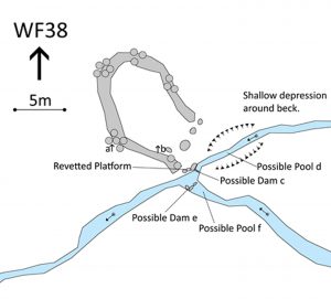
WF38 Stonestar North , NW Stickle Pike
WF35 in Area 9 South, Knott End
Remains at Knott End on a feeder beck to the River Lickle. The remains are located at SD 22420 91377 at an altitude of 160m above sea level. It is recorded in the National Park Heritage Environment Record as 65204 and is recorded as lmke203 in the Duddon Valley Local History Group survey, Ring Cairns to Reservoirs (R2R) survey in 2009. It is in Westmorland and Furness, previously South Lakes. Its condition is very poor and the certainty that it is a washfold is not possible to assess.
Unconnected stones in a marshy area.
Click on plan to enlarge then use back arrow to return to this page
Dimensions: Nothing definitive to record.
Description:
The HER records:
- Wash dub at bottom corner of field with exit through wall, fed by syke
- Buried, stone lined field drain.
The Ordnance Survey 1888 shows the position of a well with a beck flowing down the field to a cross wall.
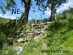
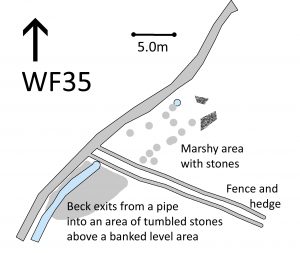
The wall has now been replaced with a doubled line of wire fencing with hedge planting in between which has been constructed since the R2R survey. Above the fence, there is an area of marshy ground with a scattering of stones which show no evidence of a structure. The water enters a buried blue plastic pipe which surfaces below the fence and spills into a large area of tumbled stone leading to a level area with an earth bank to the east. The beck flows down the field edge over a series of small falls. There is no evidence of the earlier field drain.
Recorded by: Lindsay Harrison. Keith Nixon and Ken Lindley on 4th July, 2022
WF36 in Area 9 South, Scrithwaite
Washfold above Scrithwaite on Red Moss Beck. The fold is located at SD 21630 91560 at an altitude of 160m above sea level. It is recorded in the National Park Heritage Environment Record as 61126 and is recorded as lwgs3 in the Duddon Valley Local History Group survey, Ring Cairns to Reservoirs (R2R) survey in 2009. It is in Westmorland and Furness, previously South Lakes. Its condition is good and the certainty that it is a washfold is good.
Constructed from glacial stones.
Click on plan to enlarge then use back arrow to return to this page
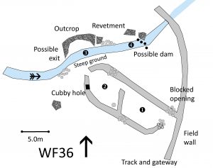
Dimensions: chamber 1- 7.1×5.0m; chamber 2- 6.0mx5.0m; pool 3- 5.0×0.7m; pool 4- 2.5×1.0m
Wall heights: fold 1.0m; field wall 1.5m
Description:
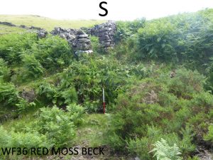
Two chamber washfold on level ground heavily infested in bracken. Chamber 2 has an exit to a cobbled revetment adjacent to stream, with over 1 m drop to the stream bed. No obvious pool but evidence of a dam wall further downstream. A possible exit from the stream was noted. Two prominent boulders noted, one outside of washfold and one within chamber 1, (not fallen from wall). Chamber 1 has a cubby hole built into the wall 0.4m wide and 0.3m high.
Extent of pool 3 is shown on the first edition of the Ordnance survey 25” sheet from 1890.
Recorded by: Lindsay Harrison, Keith Nixon and Ken Lindley on 4th July, 2022
WF37 in Area 9. Stonestar South
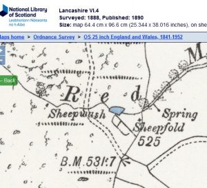
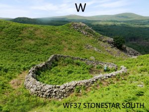
Sheepfold located on the fellside 300m east of Stonestar on an unnamed tributary of Stonestar Gill. The fold is located at SD 20466 91165 at an altitude of 156m above sea level. It is not recorded in the National Park Heritage Environment Record nor in the Duddon Valley Local History Group survey, Ring Cairns to Reservoirs (R2R) survey in 2009. It is in Westmorland and Furness, previously South Lakes. Its condition is good and the certainty that it is a washfold is poor.
Constructed from bedrock boulders, fieldstone and quarried stone.
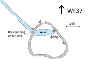
Click on plan to enlarge then use back arrow to return to this page
Dimensions: chamber: North to south from entrance 12.0m. Northeast to southwest 14.2m.
Beck within the fold: 8.0m x 3.0m
Wall height: a 1.2m; b 1.5m; c 2.0m
Wall width: 0.6 – 1.2m
Description:
This site was surveyed twice.
A single chamber fold with the stream fed by an underground spring running through it, which is unusual but the fold has certain attributes that does lend itself to a sheep wash. The fold is situated in a concealed gill surrounded by rough fell.
The robust structure of bedrock, field stone and quarried stone is a single chamber with one entrance to the north. There are no hog holes. The spring rises directly below the wall on the northeast side and runs west across the northern third of the chamber in a uniformly shallow bed covered in forget-me-nots. It runs under the wall on the northwest side with no evident water yeat. Emerging on the outside of the fold it runs for 25 metres before going back underground further down the hill. There is no evidence of a launching platform, dam or pool. The structure is in excellent condition.
Given the single chamber without associated stock management features and the lack of evidence of specific features characteristic of a washfold such as a dam or pool, it was felt that this unusual and interesting fold is not a washfold.
Recorded by: Rob Mckeever, Dave Hughes, Barbara Green and John Jordan on 9th June 2022 and Philip Minchom, Bob Mayow, Alison Matthews on 15th June 2022
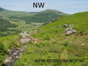
Washfold on the eastern side of the Duddon Valley on the lower slopes west of Great Stickle. It lies on the convergence of two small unnamed becks feeding into the River Duddon. The fold is located at SD 20505 91563 at an altitude of 176m above sea level. It is not recorded in the National Park Heritage Environment Record nor in the Duddon Valley Local History Group survey, Ring Cairns to Reservoirs (R2R) survey in 2009. It is in Westmorland and Furness, previously South Lakes. Its condition is moderate and the certainty that it is a washfold is good.
Constructed from fieldstone.
Click on plan to enlarge then use back arrow to return to this page
Dimensions: chamber 1- 9.8 x 7.0m; pool d 4.8 x 0.25m; pool f – 1.2 x 1.0m, depth 0.25m
Wall heights: a 0.5m; b 0.75m
Platform: 2.1m long. 0.2m high
Description:
Two small unnamed becks converge at this point. The fold comprises a single chamber of drystone walling that is tumbled in several places. There is a single entrance to the southeast that is wide with tumbled stone around it. Beside the entrance and at the convergence of the becks a possible launching platform. It is revetted with stones and a boulder at the beck bank. A dam or pool cannot be defined confidently though there are two possibilities. There is a possible relict dam ‘c’ on the northern tributary creating a potential pool ‘d’, now silted up to a few centimetres depth. There is evidence of a wider shallow depression on the banks around the stream bed. On the southern tributary another deeper pool ‘f’ lies upstream of another potential relict dam ‘e’ with some larger slabs set on end into the bed of the beck. Either pool would be potentially accessible from the platform.
Recorded by: Philip Minchom, Alison Matthews, Bob Mayow on 15th June 2022
WASHFOLD HOME PAGE ——WASHFOLD AREA MAPS PAGE —— WASHFOLD SURVEY PAGE

