Shard Survey Areas Shard Site Recording Shard Site Descriptions Survey Volunteers
“The bold and distinctive forms of vernacular farming architecture are echoed in the characterful and distinctive structures that appear dotted across the Lake District.
Dotted across the landscape are packhorse bridges, water smoots (gaps in walls where they cross streams), bee boles (holes in walls for straw bee hives) and drystone walls such as these shard fences.”
A short introduction to The English Lake District World Heritage Site
https://www.lakedistrict.gov.uk/caringfor/whs/marketing-toolkit/world-heritage-knowledge
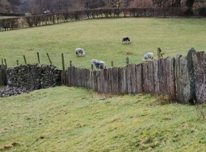
The use of upright slabs of slate to create boundaries are also referred to as shard fences or flag fences. They are recognized as one of the distinctive features of agricultural architecture. The distribution of this style of creating boundaries is not clearly defined. Dry stone walls made from field clearance rubble, beck boulders or quarried stone appear in all the valleys. Local geology makes distinctive walling where sandstone, slate, limestone and granites are found. The shard fences seem to follow the Brathay Formation of rocks which have properties for creating slabs rather than thin roofing slates.
“The geological survey around Hawkshead revealed Brathay Quarry as the source of the stone for the shard fences within the survey area. Extraction of similar stone may also have taken place along the geological formation”
M Mitchell and R Scott, 1997, quoted in The National Trust Volume 1: The Historic Landscape, Jamie Lund 2000
Many small quarries would have been short lived producing stone from simple outcrops for very local use in building. If the rock had the tendency to form flags or could be easily split into slabs, then shard fences would be a building option. However, this doesn’t explain the way a length of shards suddenly becomes a hedge or a stone wall.
Click on image to enlarge it then use back arrow to return to this page
The period of building shard fences is not known. They would seem to be more suitable for controlling cattle rather than sheep, though associated thorn hedging or modern barbed wire strands would have improved their stockproofing potential. The hedges are now disturbing the solidity of the shards so that the old boundary is being replaced with a new one. Whether they are associated with monastic time or later enclosures of common fields is not certain.
Jamie Lund’s report has some interesting dating possibilities. A ‘Flag Quarry’ is marked in Yates’ 1786 map of Lancashire in the location of the present day Brathay Quarry. Comparison of different editions of early Ordnance Survey maps shows new boundaries built between 1848 and 1898 which are now shard fences. His conclusion is that their erection is likely to have taken place over centuries.

