WASHFOLD HOME PAGE ——WASHFOLD AREA MAPS PAGE —— WASHFOLD SURVEY PAGE
These are the Park Head Road washfolds
WF30 Park Head Road South
WF31 Park Head Road North
WF32 Dunnerdale Beck, Hoses
WF33 Hollow Moss Beck, NW Stickle Pike
WF34 Kiln Bank Cross
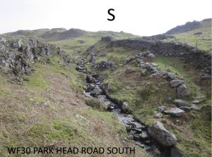
WF30 in Area 9 North, Park Head Road South
Washfold on Park Head Road on Old Park Beck. The fold is located at SD 22229 94423 at an altitude of 278m above sea level. It is recorded in the National Park Heritage Environment Record as 61102 and is recorded as lmnf48 in the Duddon Valley Local History Group survey, Ring Cairns to Reservoirs (R2R) survey in 2009. It is in Westmorland and Furness, previously South Lakes. Its condition is medium to good and the certainty that it is a washfold is good.
Constructed from natural stone with some vertical shards
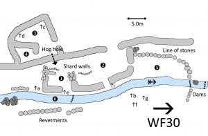
Click on plan to enlarge then use back arrow to return to this page
Dimensions: chamber 1- 6.0×3.0m; chamber 2- 15.0×7.5m; chamber3- 7.0×5.0m; chamber 4- 4.0×3.0m; chamber 5- 14.5×5.5m; Pool 6- 5.2×2.0m
Wall heights: a 1.0m; b 1.5m; c 1.4m; d 1.4m; e 1.2; f 0.8m; g 1.0; h 0.6; I 0.9; j 1.3
Description:
Complex structure. Possibly two generations of fold. Older – nearer the beck with large boulders, some upright slabs and much tumble. Newer – other side of the fell wall in good condition. Two entrances, one hog hole, exit towards revetted pool 1. Possible lower pool 2. Older structure may have had other purpose – eg shieling.
Recorded by: Roger & Liz Kingston, Margaret & Frank Dearden, Richard Johnson and Astrid Hardwick on 11th April, 2022
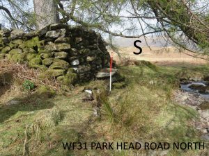
WF31 in Area 9 North, Park Head Road North
Washfold at Park Head Road on Old Park Beck. The fold is located at SD 22240 94852 at an altitude of 207m above sea level. It is recorded in the National Park Heritage Environment Record as 61103 but not recorded in the Duddon Valley Local History Group survey, Ring Cairns to Reservoirs (R2R) survey in 2009. It is in Westmorland and Furness, previously South Lakes. Its condition is medium and the certainty that it is a washfold is good.
Constructed from natural stones.
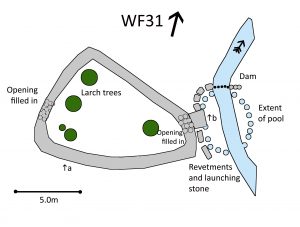
Click on plan to enlarge then use back arrow to return to this page
Dimensions: chamber 11.0×6.0m; pool 5.8×1.0m (beck) 5.8×3.8m (extended)
Wall heights: a 1.8m; b 1.2m from beck bed to launching stone
Description:
Stone built single chamber. It appears to heve been rebuilt with openings filled. Likely exit with a clear launching stone now blocked up. Potential entry on the west side. East wall with line of revetment against beck.
Recorded by: Roger & Liz Kingston, Frank & Margaret Dearden, Richard Johnson and Astrid Hardwick on 11th April, 2022
WF32 in Area 9 North, Dunnerdale Beck, Hoses
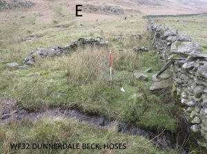
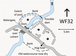
Washfold at Hoses on Dunnerdale Beck. The fold is located at SD 21867 93233 at an altitude of 207m above sea level. It is recorded in the National Park Heritage Environment Record as 61125 but not recorded in the Duddon Valley Local History Group survey, Ring Cairns to Reservoirs (R2R) survey in 2009. It is in Westmorland and Furness, previously South Lakes. Its condition is poor but the certainty that it is a washfold is good.
Constructed from natural stone similar to that used in the adjacent field wall.
Click on plan to enlarge then use back arrow to return to this page
Dimensions: chamber 1- 5.1×3.8m; chamber 2- 5.2×5.0m; pool 7.1×1.2m (beck) 7.1×6.8m (extended)
Wall heights: a 1.2m; b 1.m; c 0.7m
Description:
Chamber 1 has an obvious entrance from the gathering wall plus a hog hole into the lower field. Chamber 2 is a similar size with an opening from chamber 1 and a probable exit to the beck in the north west corner. Earth bank still obvious to the west of the fold making a substantial area for the pool. Likely dam in front of the water gate through the fell wall. Possible other structure with fallen walls and a flat stone at the head of the pool. Slab bridge over beck on far side of the wall.
Recorded by: Roger & Liz Kingston, Frank & Margaret Dearden and Richard & Eve Johnson on 14th April, 2022
WF33 in Area 9 North, Hollow Moss Beck, Kiln bank
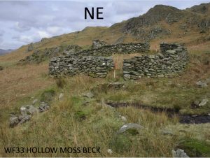
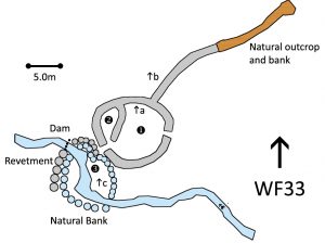
Washfold at Kiln Bank on Hollow Moss Beck. The fold is located at SD 20752 93037 at an altitude of 210m above sea level. It is recorded in the National Park Heritage Environment Record as 61095 and is recorded as lwsp25 in the Duddon Valley Local History Group survey, Ring Cairns to Reservoirs (R2R) survey in 2009. It is in Westmorland and Furness, previously South Lakes. Its condition is good and the certainty that it is a washfold is good.
Constructed from natural stones
Click on plan to enlarge then use back arrow to return to this page
Dimensions: chamber 1- 8.5×6.7m; chamber 2- 4.8×2.5m; Pool- 6.6×5.6m
Wall heights: a 1.2m; b 1.3m; c 0.7m
Description:
Natural stone circular structure. Two chambers and a gathering wall perched on a natural linear outcrop. Clear entrances to chamber 1, chamber 1 to 2 and exit to pool. Reveted wash ledge extends to dam and round part of the other side (west) of the beck to form a pool. Signs of previous (original?) course of beck against wall of chamber 1.
Recorded by: Roger & Liz Kingston, Margaret & Frank Dearden and Richard & Eve Johnson on 14th May, 2022
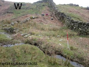
WF34 in Area 9 North, Kiln Bank Cross
Washfold at Kiln Bank Cross on a feeder beck to the River Duddon. The fold is located at SD 21302 93525 at an altitude of 202m above sea level. It maybe recorded in the National Park Heritage Environment Record as 65234 but this needs checking and is mentioned in lmnf39 in the Duddon Valley Local History Group survey, Ring Cairns to Reservoirs (R2R) survey in 2009. It is in Westmorland and Furness, previously South Lakes. Its condition is poor and the certainty that it is a washfold is medium.
Constructed from quarried and glacial stones.
Click on plan to enlarge then use back arrow to return to this page
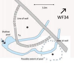
Dimensions: chamber 1- 10.6×7.6m; pool 2- possible extent 5.6×5.6m
Wall heights: a 0.5m; mostly no more than a line of stones
Description:
A single chambered enclosure against a fell wall. A steep track comes down the fell past the fold and on the a larger two chambered fold further along. This was identified in the R2R as lmnf39 at SD 21294 93507 where the sheet mentions a possible ruined washfold as surveyed here. No obvious signs of openings but most of the wall is incomplete. The beck forms a shallow pool with the main flow following a channel to an area that looks as if it has been a dammed pool in the past, before passing under the wall. A second flow goes through the middle of the fold without signs of a channel.
Recorded by: Roger & Liz Kingston, Margaret & Frank Dearden and Richard & Eve Johnson on 14th April, 2022
WASHFOLD HOME PAGE ——WASHFOLD AREA MAPS PAGE —— WASHFOLD SURVEY PAGE

