WASHFOLD HOME PAGE ——WASHFOLD AREA MAPS PAGE —— WASHFOLD SURVEY PAGE
These are the Stephenson Ground washfolds
WF24 Yewry Syke above Natty Bridge
WF25 Stephenson Ground Scale
WF26 Stephenson Ground Scale
WF27 River Lickle below Natty Bridge
WF28 Stephenson Ground Farm
WF29 Carter Ground
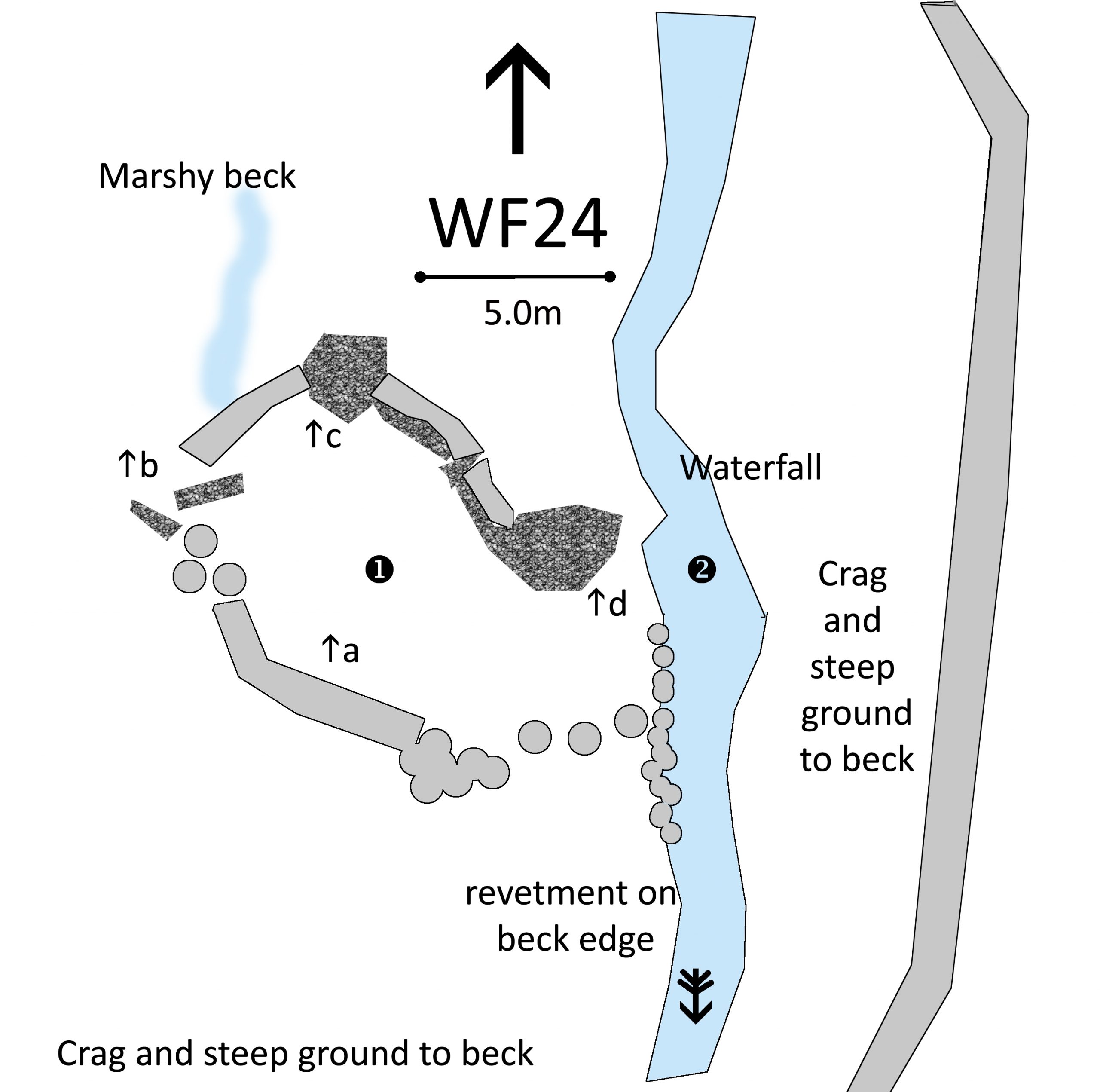
WF24 in Area 8, Yewry Syke, Natty Bridge
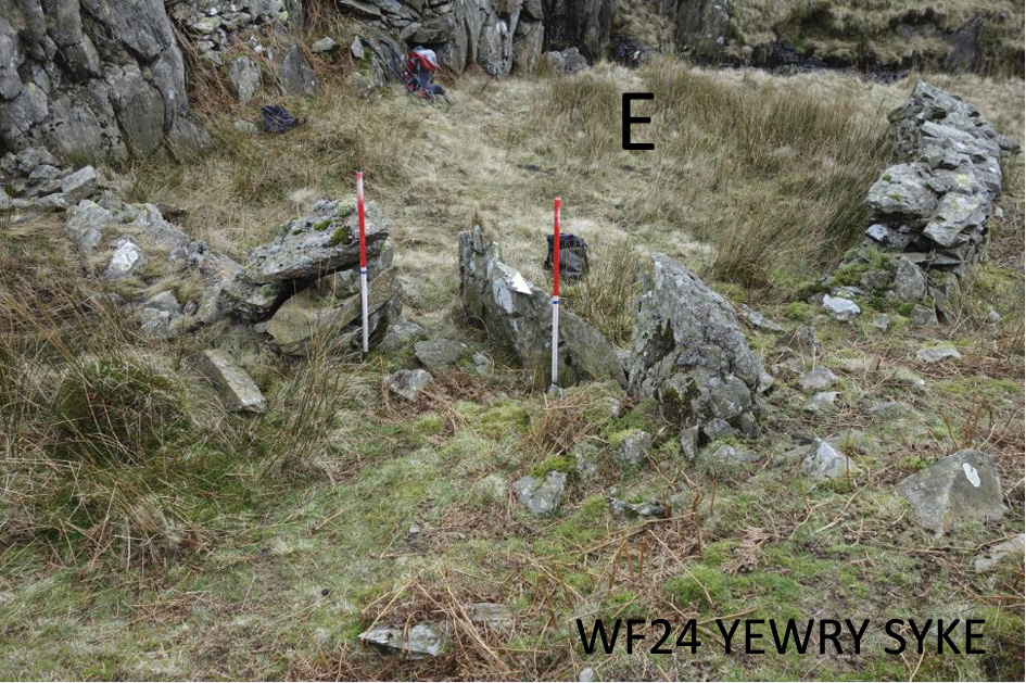
Washfold on Yewry Syke, above Natty Bridge on a feeder beck to the River Lickle. The fold is located at SD 24644 94810 at an altitude of 370m above sea level. It is recorded in the National Park Heritage Environment Record as 65024 and is recorded as ctcm02 in the Duddon Valley Local History Group survey, Ring Cairns to Reservoirs (R2R) survey in 2009. It is in Westmorland and Furness, previously South Lakes. Its condition is medium and the certainty that it is a washfold is good.
Constructed from stone and boulders in a natural hollow formed by low crags
Click on plan to enlarge then use back arrow to return to this page
Dimensions: chamber 1- 10.0×6.0m; pool- 5.0×2.5m
Wall heights: a 1.1m; b 0.9m; c 2.1m; d 1.6m
Description:
Deep hollow below a track leading down to the beck. Natural crags to east with stone wall built on them. Narrow entrance using two big shard boulders. Pool at the bottom of a waterfall. Steep grass slopes to the forest wall above the far side of the beck. Stone revetment on the bank on the fold side of the beck. Open area with access to the fell downstream.
Recorded by: Stephe Cove, Jane Coward, Ken Lindley and Keith Nixon on 10th March, 2022
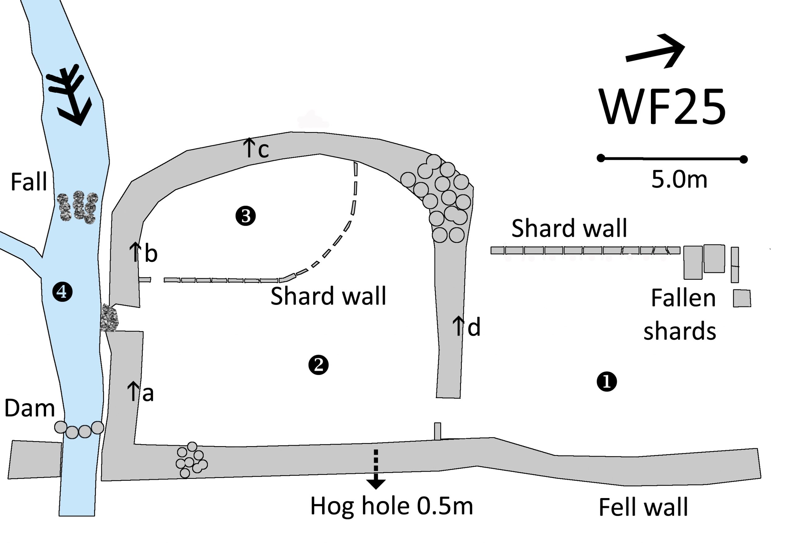
WF25 in Area 8, Stephenson Ground Scale
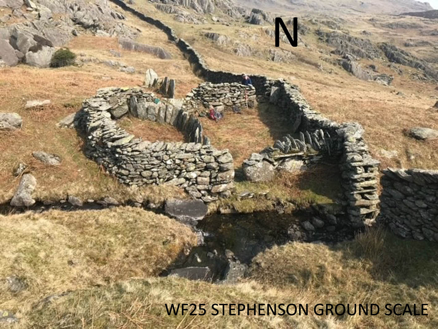
Washfold at Stephenson Ground Scale on a feeder beck to the River Lickle. The fold is located at SD 23859 94412 at an altitude of 350m above sea level. It is recorded in the National Park Heritage Environment Record as 33183 and is recorded as ctsgc08 in the Duddon Valley Local History Group survey, Ring Cairns to Reservoirs (R2R) survey in 2009. It is in Westmorland and Furness, previously South Lakes. Its condition is good and the certainty that it is a washfold is good.
Constructed from glacial stones. There are large vertical slabs – shards – forming parts of the walls
Click on plan to enlarge then use back arrow to return to this page
Dimensions: chamber 1- 10.0×6.5m; chamber 2- 10.0×9.5m; chamber3- 6.5×4.0m; pool- 2.0×2.0m
Wall heights: a 1.3m; b 1.2; c 1.4m; d 1.6m
Description:
Good example with internal and external shard walls. Narrow exit pool which is two metres square. Level ground within the fold rising gradually outside to the west. Some tumble as indicated but walls are generally in good condition. “hog hole” on western wall appears to be a field boulder incorporated into the wall rather than a moveable blockage.
Recorded by: Lindsay Harrison, Jane Coward, Keith Nixon and Ken Lindley on 23rd March, 2022
WF26 in Area 8, Stephenson Ground Scale
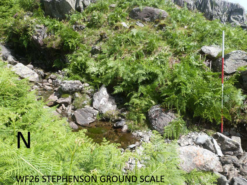
Washfold at Stephenson Ground Scale on a feeder beck to River Lickle. The fold is located at SD 24060 94439 at an altitude of 282m above sea level. It is recorded in the National Park Heritage Environment Record as 65043 and is recorded as ctsgs07 in the Duddon Valley Local History Group survey, Ring Cairns to Reservoirs (R2R) survey in 2009. It is in Westmorland and Furness, previously South Lakes. Its condition is medium to poor and the certainty that it is a washfold is poor.
Constructed from Outcrop, large ground boulders, local stone and beck stones.
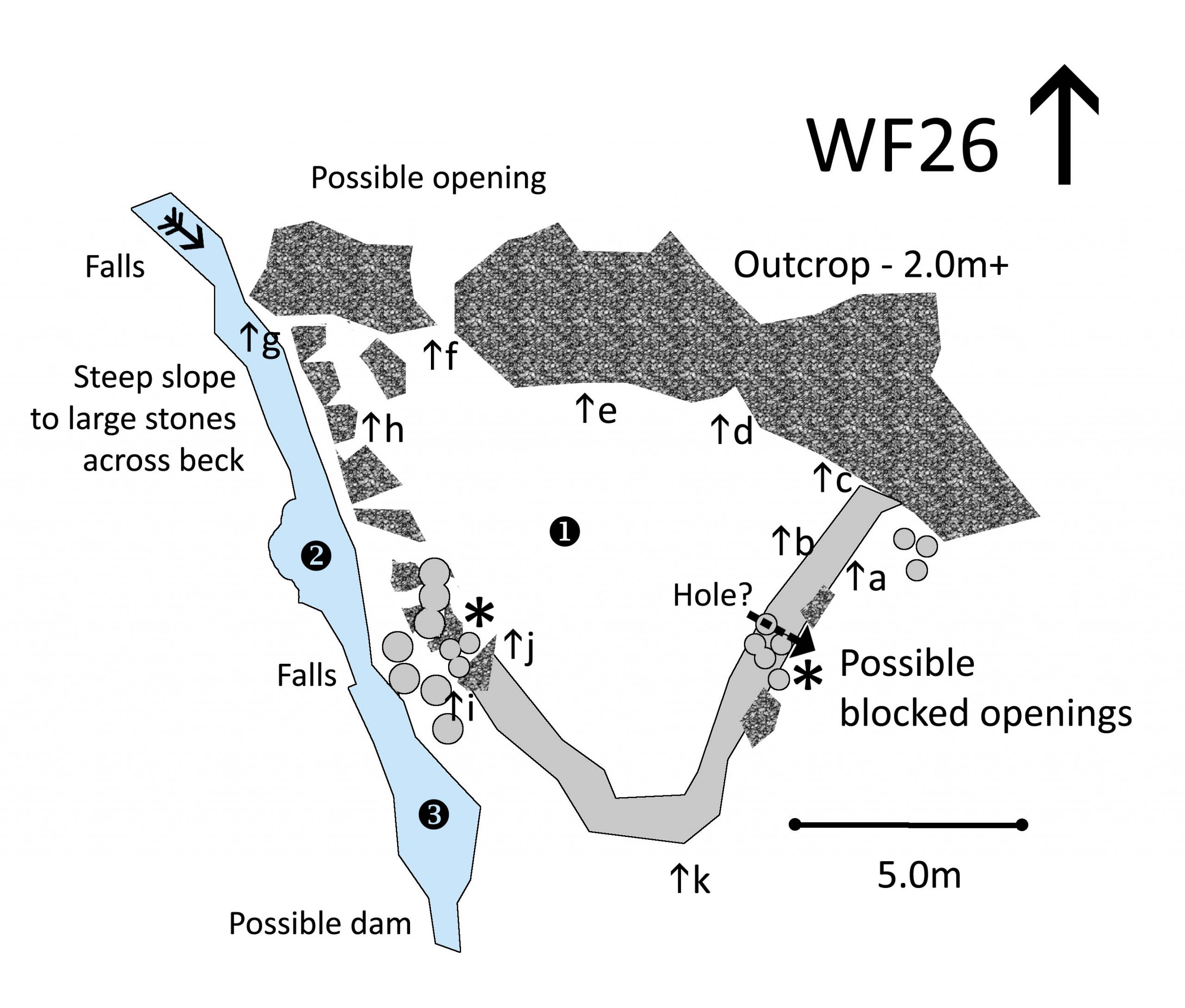
Click on plan to enlarge then use back arrow to return to this page
Dimensions: chamber 1- 9.0×8.0m; Pool 1- 2.0×2.0m; Pool 3- 3.0×2.0m
Wall and outcrop heights: a 1.5m; b 0.9m: c 1.7m; d 2.1m; e 2.1m; f 2.5m; g 4.5m; h 0.5m; i 1.3m; j 1.2m; k 1.0m
Description:
This site is just below the remains of a medieval longhouse excavated in 1990s and between washfolds WF25 and WF27. A sloping platform bounded by 2m high outcrops to the east, a steep drop to the beck on the west and a stone wall to the south. Something has happened here but it is not clear to work out what. There seems to be an entrance in the north through a gap in the outcrops. Two places look to be potential exits, both are now blocked with fallen stones. Any access to the beck is steep and rocky. There appears to be signs of a deliberate hole through the wall but it may just be where stones have fallen away
Recorded by: Stephe Cove, Roger and Liz Kingston, Jane Coward, John Jordan and Eve Bechmann-Johnson on 9th July, 2022
WF27 in Area 8, Below Natty Bridge
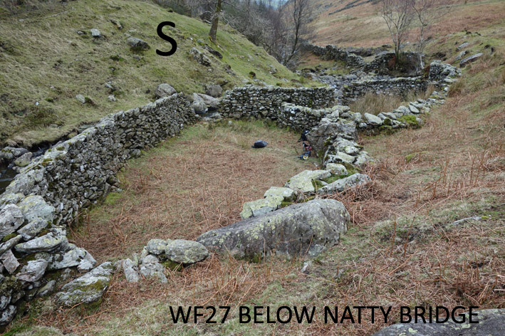
Washfold below Natty Bridge on a feeder beck to the River Lickle. The fold is located at SD 24162 94236 at an altitude of 265m above sea level. It is recorded in the National Park Heritage Environment Record as 65401 and is recorded as ctsg01 in the Duddon Valley Local History Group survey, Ring Cairns to Reservoirs (R2R) survey in 2009. It is in Westmorland and Furness, previously South Lakes/Copeland. Its condition is good and the certainty that it is a washfold is good.
Constructed from stones. There are large boulders and a small outcrop the in base of the wall.
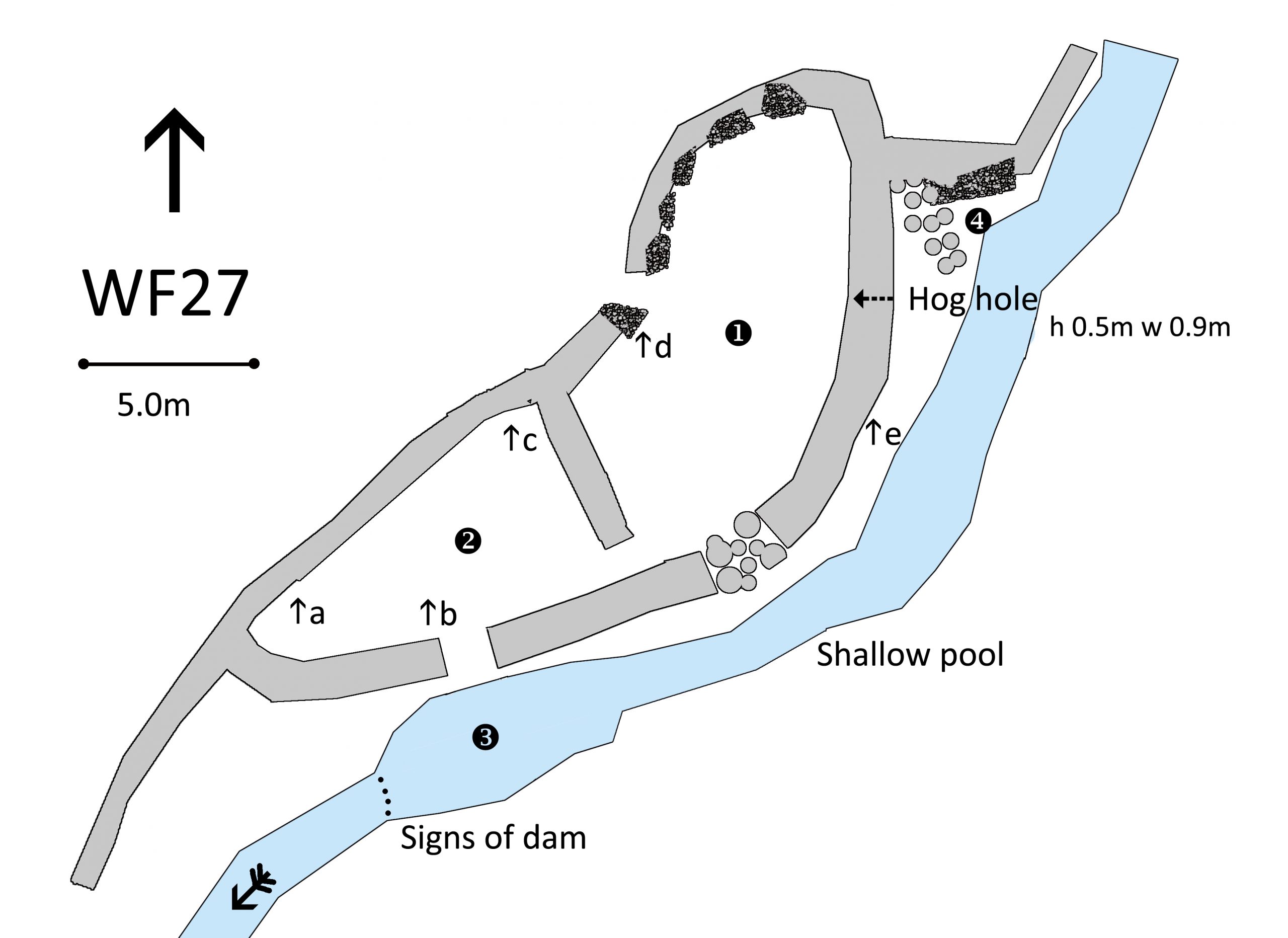
Click on plan to enlarge then use back arrow to return to this page
Dimensions: chamber 1- 13.5×5.0m; chamber 2- 10.0×5.0m; pool 3- 6.0×3.0m
Wall heights: a 0.7m; b 1.5m; c 0.5m; d 1.2m; e 1.4m
Description:
A well built two chambered fold below the track. The entrance to the gathering chamber is between two large blocks and further boulders have wall sections built on top. One wall section has collapsed. There is a hog hole in the top corner leading to the beck. A narrow entrance leads to the dipping chamber where there is a long drop to the pool. Doesn’t look as if there was a step. Signs that the pool may have been deepened by damming. At the north end there is a strange ramp down to the pool which may have been the route for sheep to return to the fell.
Recorded by: Stephe Cove, Jane Coward, Ken Lindley and Keith Nixon, on 10th March, 2022
WF28 in Area 8, Stephenson Ground Farm
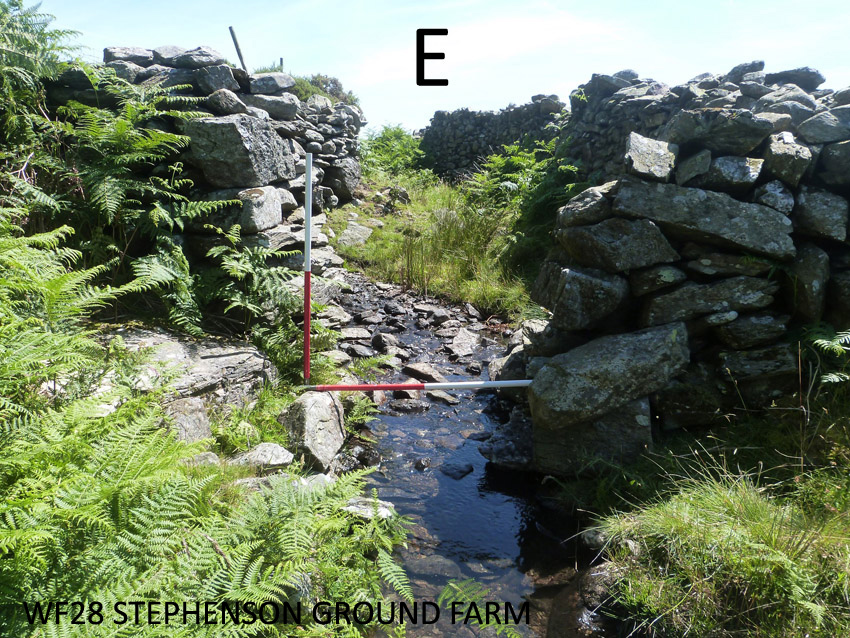
Washfold near Stephenson Ground Farm on a feeder beck to River Lickle. The fold is located at SD 23502 93350 at an altitude of 245m above sea level. It is recorded in the National Park Heritage Environment Record as 65044 and is recorded as ctsgs03 in the Duddon Valley Local History Group survey, Ring Cairns to Reservoirs (R2R) survey in 2009. It is in Westmorland and Furness, previously South Lakes. Its condition is good and the certainty that it is a washfold is medium to poor.
Constructed from local stone and beck stones.
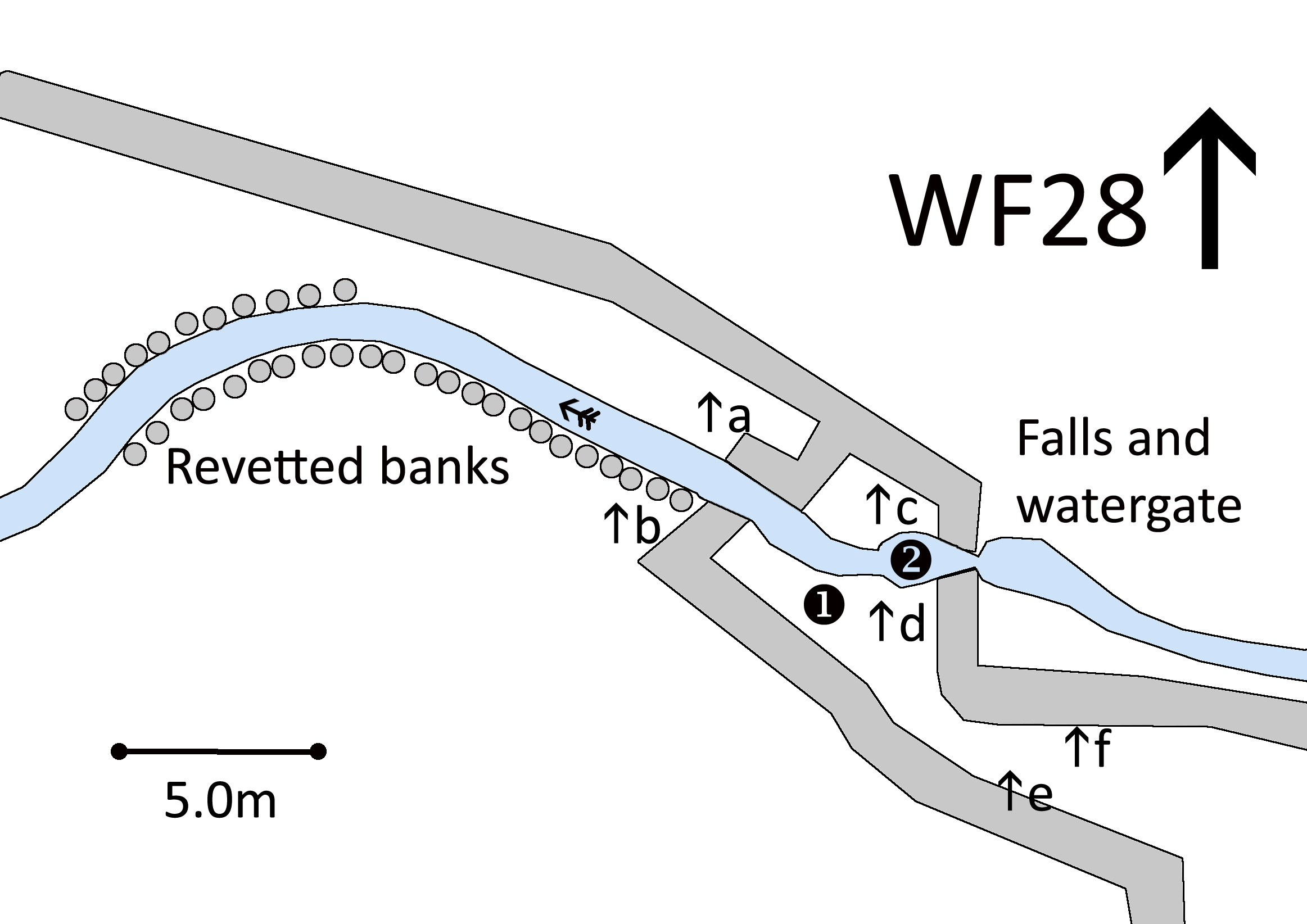
Click on plan to enlarge then use back arrow to return to this page
Dimensions: chamber 1- 6.0×4.5m; pool 2- 1.5×1.0m
Wall heights: a 1.7m; b 1.9m; c 2.1m; d 2.1m; e 1.4m; f 1.4m
Description:
Something was happening here but it isn’t clear just what. Two field walls form a funnel into a wider chamber. The beck comes from the fellside down a small fall and through a watergate into a small pool which exits through an opening between the two walls. The beck is then revetted for about 20m downstream on one side and 12m on the other bank. If the wall opening was dammed to fill the pool, sheep would have to clamber over the dam to exit into the field.
Recorded by: Stephe Cove, Roger and Liz Kingston, Jane Coward, John Jordan, Eve Bechmann-Johnson on 9th July, 2022
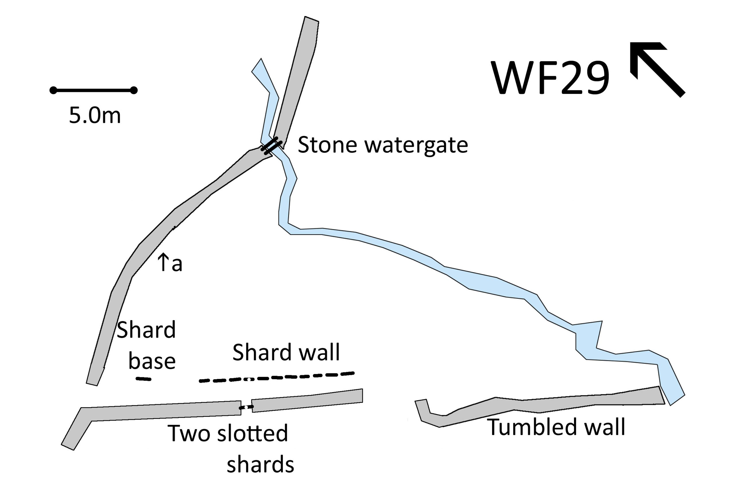
Washfold Carter Ground on a feeder beck to the River Lickle. The fold is located at SD 23016 92438 at an altitude of 160m above sea level. It is recorded in the National Park Heritage Environment Record as 65100 and is recorded as lmcg05 in the Duddon Valley Local History Group survey, Ring Cairns to Reservoirs (R2R) survey in 2009. It is in Westmorland and Furness, previously South Lakes. Its condition is poor and the certainty that it is a washfold is medium.
Constructed from glacial stones and thin slate slabs fixed vertically in the ground. These are called shard walls or stone fences.
Click on plan to enlarge then use back arrow to return to this page
Dimensions: No definable able to measure. Remaining shard wall is 7.7m long. Individual shards are 0.6m wide and 0.8m tall.
Wall heights: a 1.6m
Description:
No remains of chambers, pools or evidence of dammed beck. The area is heavily trampled by cattle. All that is still visible is a length of shard wall running parallel to the field wall. It seems likely that this ran along to the gate way as there is the base of a broken shard further up the field. One shard has a deep slot and there is a matching stone set in the thickness of the drystone wall across the passage. A local farmer suggests that this would have allowed some sort of barrier to have closed the passage. There is a 2 bar stone gate where the beck comes through the wall.
Recorded by: Lindsay Harrison, Keith Nixon and Ken Lindley on 4th July, 2022
WASHFOLD HOME PAGE ——WASHFOLD AREA MAPS PAGE —— WASHFOLD SURVEY PAGE