WASHFOLD HOME PAGE ——WASHFOLD AREA MAPS PAGE —— WASHFOLD SURVEY PAGE
These are the Crosbythwaite washfolds
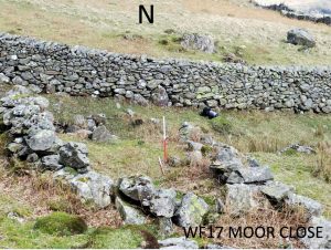
WF17 Moor Close, Birker Fell
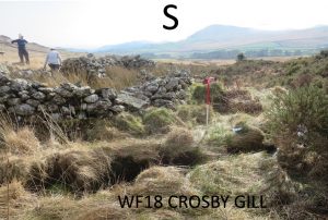
WF18 Crosby Gill, Birker Fell
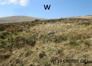
WF19 Crosby Gill, Birker Fell
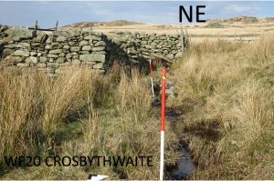
WF20 Crosbythwaite
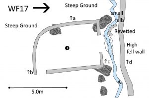
WF17 in Area 6, Moor Close Birker Fell
Washfold at Moor Close on a feeder beck into the River Duddon. The fold is located at SD 20381 95502 at an altitude of 257m above sea level. It is recorded in the National Park Heritage Environment Record as 61101 and is recorded as mcmh07 in the Duddon Valley Local History Group survey, Ring Cairns to Reservoirs (R2R) survey in 2009. It is in Cumberland, previously Copeland. Its condition is medium and the certainty that it is a washfold is good.
Constructed from large boulders existing outcrops of rock and stones.
Click on plan to enlarge then use back arrow to return to this page
Dimensions: chamber 1- 7.0×3.9m; pool 2- 4.0×1.1m
Wall heights: a 1.2m; b 0.9m; c 1.2m; d 1.7m
Description:
Single chamber with a curved wall on the western side below steeply falling fellside enclosing a natural platform. Large boulders and outcropping rock are used for the base of the rough walls. The water comes over a small fall with revetting on both sides to channel the flow. One metre drop to the narrow pool into the beck. Hardly any flow on the day of visit. It would require a much greater flow to create a pool of any useable depth. Tumble in the beck below the pool could be evidence of damming or fallen from the wall
Recorded by: Stephe Cove and Dave Hughes on 26th March, 2022
Return to the top of the page
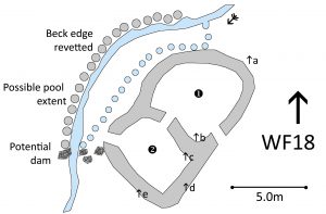
WF18 in Area 6, Crosby Gill, Birker Fell
Washfold on Birker Fell on Crosby Gill. The fold is located at SD 19639 95537 at an altitude of 245m above sea level. It is recorded in the National Park Heritage Environment Record as 61096 and is recorded as mclw15 in the Duddon Valley Local History Group survey, Ring Cairns to Reservoirs (R2R) survey in 2009. It is in Cumberland, previously Copeland. Its condition is medium and the certainty that it is a washfold is good.
Constructed from natural stone and large cobbles
Click on plan to enlarge then use back arrow to return to this page
Dimensions: chamber 1- 6.5×5.5m; chamber 2- 5.3×4.2m; pool 3- 8.5×0.5m (beck) 8.5×1.6m (dammed)
Wall heights: a 1.25m; b 1.3m; c 1.4m; d 1.6m; e 1.5m
Description:
Two chambers, clear entry, opening between chambers and exit to beck. Remains of a wall from chamber exit to dam. Flattish area between washfold and pool. Long revetment on far side of beck from dam going upstream. Upper part of pool seems silted up. Animals would exit pool upstream. Gorse obscures northern end of chamber 1.
Recorded by: Roger & Liz Kingston, Frank & Margaret Dearden and Richard Johnson on 26th March, 2022
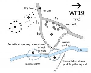
Washfold at Birker Fell on Crosby Gill. The fold is located at SD 19217 95535at an altitude of 250m above sea level. It is not recorded in the National Park Heritage Environment Record and not recorded in the Duddon Valley Local History Group survey, Ring Cairns to Reservoirs (R2R) survey in 2009. It is in Cumberland, previously Copeland. Its condition is poor and the certainty that it is a washfold is medium.
Constructed from natural stones. There are some very large cobbles
Click on plan to enlarge then use back arrow to return to this page
Dimensions: chamber 1- 24.4×22.0m; pool 2- 6.0mx0.5m (beck) x5.0m (extended); pool 3- 6x1m (beck) x5.0m (extended); 4- 6.0×5.0m; 5- 7.0×5.0m
Wall heights: a 1.7m; b 1.4m; c 1.2m
Description:
A single large triangular pen. Back wall of chamber is existing fell wall. Most walls are single skin large cobbles, with some places doubled skinned. Large stones against and along the west wall- possibly from a previous wall. One large apparent entrance. Two potential exits to possible pools. Three possible pools but it is unclear. The small beck is silted and choked with reeds.
Abundant signs of wall/structures adjacent to the site made of large stones and cobbles.
Recorded by: Roger & Liz Kingston, Frank & Margaret Dearden and Richard Johnson on 26th March, 2022
Washfold at Crosbythwaite on a feeder beck to Crosby Gill. The fold is located at SD 19599 95120 at an altitude of 208m above sea level. It is not recorded in the National Park Heritage Environment Record and not recorded in the Duddon Valley Local History Group survey, Ring Cairns to Reservoirs (R2R) survey in 2009. It is in Cumberland, previously Copeland. Its condition is good but the certainty that it is a washfold is poor.
Constructed from natural stones. Some of them are dressed.
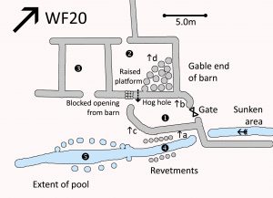
Click on plan to enlarge then use back arrow to return to this page
Dimensions: chamber 1- 5.5×2.5m; barn 2- 7.0×5.5m; barn3- 5.5×4.5m; pool 4- 7.0mx1.0m; pool 5- 7.0×1.5m (beck) x2.5m (extended)
Wall heights: a 1.5m; b 1.5m; c 1.5m; d 1.2m
Description:
Single chamber between beck and derelict barn building. Clear openings each end of the chamber. Hog into the chamber from the barn. Potential pools 4 and 5. Pool 4 seems very narrow and unlikely and pool 5 is very shallow and also unlikely. There is a sunken area to the north west of the wooden gated exit. This seems to another unlikely area for a pool and it seems more likely that this was part of a gathering wall.
The barn shows signs that it has been altered over time with blocked doorways. Barn 2 has a raised platform in a quarter circle about 1.2m above the rest of the floor.
Recorded by: Roger & Liz Kingston, Frank & Margaret Dearden and Richard Johnson on 26th March, 2022
WASHFOLD HOME PAGE ——WASHFOLD AREA MAPS PAGE —— WASHFOLD SURVEY PAGE

