WASHFOLD HOME PAGE ——WASHFOLD AREA MAPS PAGE —— WASHFOLD SURVEY PAGE
These are the Walna Scar washfolds
WF10 Longhouse Gill
WF11 Broad Hawse North, Long House
WF12 Broad Hawse South, Long House
WF13 Wash Dub Beck, Turner Hall
Washfold high on Seathwaite Fells about 2km from Long House Farm on Long House Gill. The fold is located at SD 25551 97147 at an altitude of 520m above sea level. It is recorded in the National Park Heritage Environment Record as 61088, and is record mcdc07 in the Duddon Valley Local History Group survey, Ring Cairns to Reservoirs (R2R) survey in 2009. It is in Westmorland and Furness, previously South Lakes. Its condition is poor and the certainty that it is a washfold is poor.
Constructed from field stone and bedrock.
Click on plan to enlarge then use back arrow to return to this page
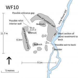
Dimensions: external NS-EW 11.7×9.1m; internal NS-EW 7.0×7.5m;
Description:
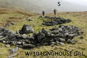
The possible washfold lies close beside Long House Gill high on Seathwaite Fells about 2km from Long House Farm. The structure is largely destroyed comprising 2 arcs of derelict tumbled wall and scattered stones. The maximum height is 0.3m. There is a wall gap that may be an entrance to the northwest. A concentration of small boulders extending eastwards into the fold from the west side may represent a relict internal wall. Another gap to the south east may have been an exit to the beck. Along the eastern side directly beside the beck is a short section of stone-built revetment. The structure is built on and around a number of large boulders and bedrock outcrops. A boulder beside the beck just to the south is a potential damming point but there is no sign of dam or pool.
Given the very poor condition, its remote location, the presence of two other convenient washfolds further down the valley and the lack of conclusive identifying features it is difficult to define this as a washfold with confidence.
Recorded by: Philip Minchom, Bob Mayow, Alison Matthews on 23 rd March, 2022
WF11 Broad Hawse North, Long House
Washfold at Broad Hawes (North) on a feeder beck to Long House Gill. The fold is located at SD 24346 96832 at an altitude of 256m above sea level. It is recorded in the National Park Heritage Environment Record as 65171 and is record lmlhc02 in the Duddon Valley Local History Group survey, Ring Cairns to Reservoirs (R2R) survey in 2009. It is Westmorland and Furness, previously South Lakes. Its condition and certainty are both considered good.
It is built of field stones and using outcrops.
Click on plan to enlarge then use back arrow to return to this page
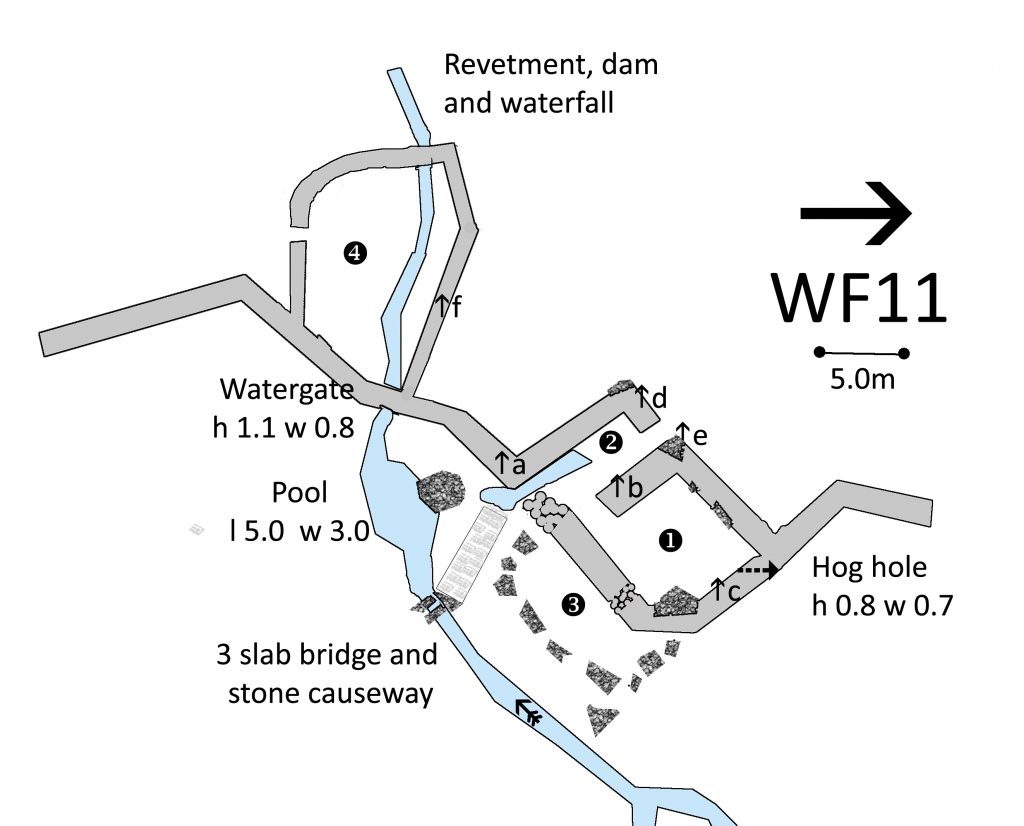
Dimensions: chamber 1- 8.0×8.0m; chamber 2- 8.0×3.0m; chamber 3- 9.0×5.0m; chamber 4- 15.0×10.om
Wall heights: a 1.4m; b 1.7m; c 1.6m; d 1.4m; e 1.8m; f 0.9m
Description:
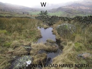
This two chambered washfold is associated two separate areas which seem to relate to earlier developments as there are several other enclosures in the area Chamber 1 is on the slope with a hoghole in the top corner. Chamber 2 has entrance and exit to pool with over ten centimetres of water pooled on the exit at the southern end. Chamber 3 is marked out with a series of large boulders and a small outcrop. Chamber 4 is complete with an entrance and the beck running in through an intricate watergate and out over a dammed revetment. There is a clapper bridge over the beck with a stone paved causeway alongside the pool.
Recorded by: Stephe Cove, Stan Aspinall and Bob Mayow on 17th March, 2022
WF12 Broad Hawse South, Long House
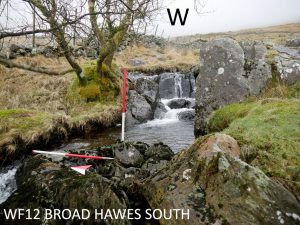
Washfold at Broad Hawes (South) on a feeder beck to Long House Gill. The fold is located at SD 24245 96792 at an altitude of 240m above sea level. It is not recorded in the National Park Heritage Environment Record and is record lmlhc02 in the Duddon Valley Local History Group survey, Ring Cairns to Reservoirs (R2R) survey in 2009. It is in Westmorland and Furness, previously South Lakes. Its condition is medium and the certainty that it is a washfold is medium to poor as there is a substantial and difficult drop from the fold to the beck.
Constructed from glacial stones. There are large boulders and small outcrops the in base of the wall including a flat slab forming an entrance in the fold.
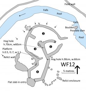
Click on plan to enlarge then use back arrow to return to this page
Dimensions: chamber 1- 9.3×4.5m; chamber 2- 9.1×4.4m; chamber 3- 9.9×5.3m; chamber 4- 5.0×4.1m; lower pool- 3.0×2.5m; upper pool- 6.5×3.7m.
Wall Heights: a 1.3m; b 1.5m; c 0.9m
Hog hole from chamber 2 to 4: h 0.7m, w 0.6m
Hog hole from chamber 1 to outside: h 0.9m, w 0.6m
Platform in chamber 2: h 0.5m, l 1.7m, w 1.1m.
Description:
The washfold lies by the Walna Scar Road directly beside Long House Gill. It comprises a complex of 4 chambers with entrances at the south towards the road and the north approximately 3 metres from the beck. Entry from the south is over a massive flat-topped boulder on which the ends of the washfold are built. There is a hog hole between chambers 2 and 4 largely blocked by rubble. Another runs from chamber 1 to the outside on the east. The area around has evidence of many relict walls. There is one relict wall enclosing an area directly adjacent to the west and another to the east. A low platform of stone fills the southwest corner of chamber 2. To the north and west the ground drops steeply to the beck which falls in two waterfalls. The north entrance is just above the level of the beck and a large boulder narrows the stream at that point creating a potential dam point with a pool above it. A steep but manageable slope runs down from beside the north entrance to a lower pool. No defined entry or exit points were identified at either pool.
Recorded by: Philip Minchom, Stephe Cove, Stan Aspinall and Bob Mayow on 17th March, 2022
WF13 Wash Dub Beck, Turner Hall
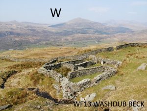
Washfold 1km east of Turner Hall Farm, Seathwaite on Wash Dub Beck. The fold is located at SD 24371 95853 at an altitude of 365m above sea level. It is recorded in the National Park Heritage Environment Record as 61091, and is record ctwp07 in the Duddon Valley Local History Group survey, Ring Cairns to Reservoirs (R2R) survey in 2009. It is in Westmorland and Furness, previously South Lakes. Its condition is good and the certainty that it is a washfold is good.
Constructed from field stone and bedrock.
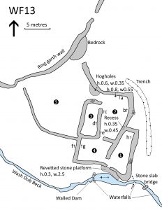
Click on plan to enlarge then use back arrow to return to this page
Dimensions: chamber 1- 14.1×12.1m; chamber 2- 8.4×5.0m; chamber 3- 6.5×2.5m; chamber 4- 5.6×4.4m; chamber 5- 8.0×3.3m; pool: 5.0×1.7m
Wall heights: a 1.4m; b 0.9m; c 1.2m; d 1.4m; e 1.3m; f 1.6m; g 1.1m; h 1.9m
Description:
The washfold is located high on the steep eastern side of the Duddon Valley about 1km above Turner Hall Farm, Seathwaite, and a short way below Walna Scar Quarry. It is just outside the ring garth, utilising that wall as its north-western boundary. There is a wall gap in the Ring Garth about 9m north of the fold. Wash Dub Beck runs in a series of waterfalls and pools down the hillside directly to the south.
It comprises a complex of 5 chambers interconnected by wall gaps and with 2 hog holes to the north leading outside. That from chamber 2 has a large slab of slate present inside to block off access as required. The hog hole from chamber 1 has a steel gate on the inside. This is on a hanging slate stoup and is functional. There is also external access to chamber 1, which lies directly beside the ring garth wall, through wall gaps at the northern and western corners. A wall gap in the southern wall of chamber 5 leads directly onto a stone platform above the beck with a sloping path running from it into the water. The beck is shallow at that point but there is evidence of a stone-built dam directly downstream and it is possible that there was a pool that has silted up. The bank opposite to the platform is not very high but may have been washed away by flooding at some point.
The arrangement of the pens and the beck, with its name of Wash Dub Beck confirm the likelihood that this is a washfold.
Several features were noted. In the eastern wall inside chamber 2 is a small recess with single slabs for shelf and lintel. It contained a selection of glass bottles and jars plus the plastic lids of margarine tubs.
Just upstream from the fold a small single slab stone bridge crosses the beck where it is deeply cut.
To the east of the fold, a small trench has been dug leading from beside the beck around the northern end. It is possibly part of a mechanism to control the flow of water down to the pool below.
The general condition of the fold is good with some areas of wall tumble. The presence of the steel gate, a rusted bucket, the contents of the recess and several old hurdles lying inside suggest it has been in use relatively recently.
Recorded by: Philip Minchom, Alison Matthews, Bob Mayow on 23rd March, 2022
WASHFOLD HOME PAGE ——WASHFOLD AREA MAPS PAGE —— WASHFOLD SURVEY

