WASHFOLD HOME PAGE ——WASHFOLD AREA MAPS PAGE —— WASHFOLD SURVEY PAGE
These are the Harter Forest washfolds
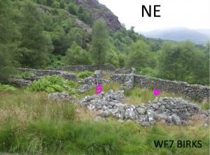
WF7 South of Buck Crag, Birks
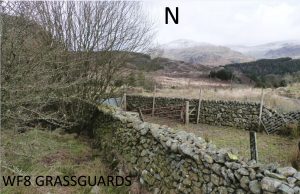
WF8 Grassguards West
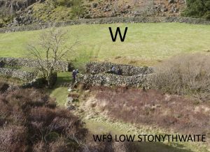
WF9 Low Stonythwaite
WF7 in Area 3, South of Buck Crag, Birks
Washfold at Buck Crag above Birks on a feeder beck to the River Duddon. The fold is located at SD 22889 99172 at an altitude of 238m above sea level. It is recorded in the National Park Heritage Environment Record as 32638 and is recorded as mchtf11 in the Duddon Valley Local History Group survey, Ring Cairns to Reservoirs (R2R) survey in 2009. It is in Cumberland, previously Copeland. Its condition is good and the certainty that it is a washfold is good.
Constructed from glacial stones.
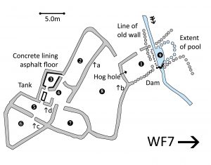 Click on plan to enlarge then use back arrow to return to this page
Dimensions: Chamber 1- 5.4×3.2m; chamber 2- 11.8×4.5m; chamber 3- 5.1×2.5m; chamber 4a- 4.5×3.7m; chamber 4b (trough)-2.7×2.4m; chamber 5- 9.2×3.1m; chamber 6- 9.0×7.0m; chamber 7- 7.5×4.2m; chamber 8- 13.0×12.5m; pool- 4.7×3.0m (full extent 6.9×4.7m)
Wall heights: a 1.9m; b 0.7m; c 1.4m; d 1.0m
Description:
A large area of chambers on area of fairly level ground just above the forestry road above Birks Outdoor Centre. It’s clear that chambers have been added/altered over time. Some are infested in bracken and chamber 2 has some birch saplings growing. Chamber 3 has a concrete lining to the inside wall and leads in chamber 4b where there is a concrete trough 2.3×0.6m which is 0.5m deep inside and the rim is 0.7m above ground level externally. There is a series of relict walls along the beck which is revetted above the pool. This is still dammed as a water intake for the Centre but it is clear that a larger area would have been formed in the past. There is hog hole between chambers 8 and 1 but no obvious way of linking the other chambers into the one above the pool.
Recorded by: Rob Mckeever, Barbara Green, John Jordan, Celia Caulcott and Dave Hughes on 23rd February, 2022 and Stephe Cove and Dave Hughes on 22nd July, 2022
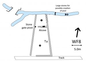
WF8 in Area 3, Grassguards West
Washfold at Grassguards on Grassguards Gill. The fold is located at SD 22153 98131 at an altitude of 247m above sea level. It is recorded in the National Park Heritage Environment Record as 61099 but is not recorded in the Duddon Valley Local History Group survey, Ring Cairns to Reservoirs (R2R) survey in 2009. It is in Cumberland, previously Copeland. Its condition is good and the certainty that it is a washfold is good.
Constructed from field clearance stone
Click on plan to enlarge then use back arrow to return to this page
Dimensions: chamber 1- 6.0×5.0m; chamber 2- 13.0×9.0m; chamber3- 9.0×5.0m
Wall heights: generally 1.4m
Wall width: generally 0.65m
Description:
Situated on open ground inside the fell wall. A new bridge has been constructed adjacent due to forestry activity. Evidence of a weir constructed to increase the depth of the stream. Storage alcove in wall of washfold. Stone gate pivot (top) in situ.
Recorded by: Rob McKeevor, Barbara Green, John Jordan, Celia Caulcott, Dave Hughes on 23rd February, 2022
WF9 in Area 3, Low Stonythwaite
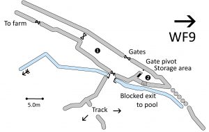
Washfold at Low Stoneythwaite on Rake Beck. The fold is located at SD 22064 96931 at an altitude of 228m above sea level. It is recorded in the National Park Heritage Environment Record as 61105 but not recorded in the Duddon Valley Local History Group survey, Ring Cairns to Reservoirs (R2R) survey in 2009. It is in Cumberland, previously Copeland. Its condition is good and the certainty that it is a washfold is good.
Constructed from field clearance stones.
Click on plan to enlarge then use back arrow to return to this page
Dimensions: chamber 1- 19.0×5.0m; chamber 2- 5.0×1.5m; pool- 15.0×3.0m
Wall height: generally 1.6m
Description:
Situated in open fell to the east and against an enclosed field to the west. The washfold is accessed across a bridge and via a gate. The access from the washfold to the beck is now blocked up but clearly evident. A stone gate top pivot to the washfold is in situ. A long second chamber is formed from the track to the farm. Currently used as a sheepfold by High Wallowbarrow farm (from discussion with farmer, Chris Chin).
Recorded by: Rob Mckeever, Barbara Green, John Jordan, Celia Caulcott and Dave Hughes on 23rd February, 2022 and Rob Mckeever, Dave Hughes, Barbara Green and John Jordan on 14th April, 2022
WASHFOLD HOME PAGE ——WASHFOLD AREA MAPS PAGE —— WASHFOLD SURVEY PAGE

