WASHFOLD HOME PAGE ——WASHFOLD AREA MAPS PAGE —— WASHFOLD SURVEY PAGE
These are the Seathwaite Tarn washfolds
WF4 Head of Seathwaite Tarn
WF5 Black Allens, Seathwaite Tarn
WF6 Tarn Beck
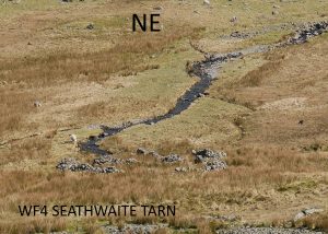
Washfold at the head of Seathwaite Tarn on a feeder beck to Tarn Head Beck. The fold is located at SD 26312 99190 at an altitude of 385m above sea level. It is recorded in the National Park Heritage Environment Record as 61098, and is record mcdc41 in the Duddon Valley Local History Group survey, Ring Cairns to Reservoirs (R2R) survey in 2009. It is in Westmorland and Furness, previously South Lakes. Its condition is good and the certainty that it is a washfold is good.
Constructed from field stones.
Click on plan to enlarge then use back arrow to return to this page
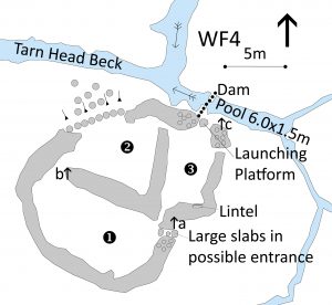
Dimensions: chamber 1- 11.5×5.3m; chamber 2- 6.8×6.1m; chamber 3- 6.4×3.4m; pool 4- 6.0×1.5m
Wall heights: a 0.75m; b 1.0m; c 1.0m.
Description:
The remote washfold is situated by Tarn Head Moss well beyond the top of Seathwaite Tarn in the valley between Grey Friar and Goat’s Hause. The building of the dam extended the tarn some 250 metres closer than originally. Seathwaite Copper mine was close by in the valley, with signs of workings all around. The pool is supplied by small becks from the hillside to the south and drains out into Tarn Head Beck just below. The fold comprises three chambers built of field stone with several areas of tumble and almost complete tumble of the perimeter wall on the north side towards the beck. There is an entrance by the beck on the eastern side of Chamber 3 and another possible entry on the east side of Chamber 1. All three chambers have passageways between them. From Chamber 3, a slab forms a launching platform directly above the pool. The dam is still evident just downstream of the launching slab. The pool itself is silted but still 0.5m at its deepest. It is neatly rectangular and much wider than its feeder streams suggesting it has been partially artificially created. On the south wall of Chamber 3 a large slab has been built into the internal side as if to form the lintel of an aperture, but it is full of tumbled debris and its original purpose is unclear.
Recorded by: Philip Minchom, Stan Aspinall, Bob Mayow and Alison Matthews on 20th April, 2022.
WF5 Black Allens, Seathwaite Tarn
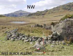
Washfold to the east of Black Allens and below Seathwaite reservoir dam, on a gill in boggy ground that was the course of Tarn Beck prior to the dam construction. The fold is located at SD 24850 98578 at an altitude of 350m. It is recorded in the National Park Heritage Environment Record as 64725, and is record mcstt13 in the Duddon Valley Local History Group survey, Ring Cairns to Reservoirs (R2R) survey in 2009. It is in Westmorland and Furness, previously South Lakes. Its condition is poor and the certainty that it was a washfold is medium.
Constructed from natural outcrop with field stone walling between.
Click on plan to enlarge then use back arrow to return to this page
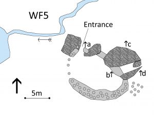
Dimensions: chamber 1- 11.4×7.2m
Wall heights: a 1.2m; b 1.0m; c 3.1m; d 2.5m.
Description:
Lying in a boggy area to the east of the rocky outcrop of Black Allens, the fold is roughly 100m below the dam of Seathwaite Tarn. It makes use of two large rock outcrops and some flat natural slabs with rough boulder infill in the gaps between to form a single chamber. A small gill runs past the north of the fold to a reed filled pool a short distance to the west. The southern and western sides have a drystone construction now largely tumbled. There is an entrance formed between a quoin ended dry stone wall and natural outcrop at the northwest corner with a flat slab of bedrock extending towards the gill that might have been a launching platform. Currently there is very limited flow of water, no sign of a dam and no evident pool in the boggy ground immediately beside the fold throwing doubt on this being used as a washfold. However, the main stream of Tarn Beck prior to the dam construction ran along the line of the current gill, past the site of the fold and may have made it an effective washfold. The crude structure is similar to other fellside sheep folds.
Recorded by: Philip Minchom, Stan Aspinall, Bob Mayow and Alison Matthews on 20 April, 2022.
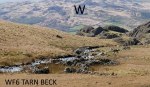
Washfold located 650m below Seathwaite tarn dam on the right bank of Tarn Beck at SD 24406 98654, at an altitude of 335m. It is recorded in the National Park Heritage Environment Record as 61090, and is record mcstt25 in the Duddon Valley Local History Group survey, Ring Cairns to Reservoirs (R2R) survey in 2009. It is in Westmorland and Furness, previously South Lakes. Its condition is good and the certainty that it is a washfold is good.
Constructed from field stone.
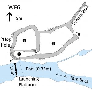
Click on plan to enlarge then use back arrow to return to this page
Dimensions: chamber 1- 13.0×7.5m; chamber 2- 8.3×6.8m; chamber 3- 8.9×2.5m; pool 4- 15.6×5.4m
Wall heights: a 1.0m; b 0.6m; c 0.5m
Wall width: approximately 1.0m.
Description:
The washfold, stands on the right bank of Tarn Beck, 650 metres west of Seathwaite Tarn. It comprises 3 chambers and a driving wall 10m long at the north east corner. The main entrance is through the eastern wall into Chamber 1, the largest of the chambers. An exit at the south western corner of Chamber 1 leads into Chamber 3 close by another gap opening into Chamber 2. In the west wall of Chamber 2, largely obscured by tumble, is a possible hog hole leading to the outside. Chamber 3 is almost a corridor leading to the stone slab of the launching platform at the southwest corner. The platform leads directly to the beck edge just upstream of the remains of the dam. The 6 inch OS map, 1886-1913 indicates stepping stones along the line of the dam. Scattered boulders in the beck may have been part of this. The pool has been cleared of the boulders that are frequent up and downstream. It is now silted and relatively shallow at about 0.35 m. The construction is drystone walling using field stone.
Recorded by: Philip Minchom, Stan Aspinall, Bob Mayow and Alison Matthews on 20th April, 2022.
WASHFOLD HOME PAGE ——WASHFOLD AREA MAPS PAGE —— WASHFOLD SURVEY PAGE

