WASHFOLD HOME PAGE ——WASHFOLD AREA MAPS PAGE —— WASHFOLD SURVEY PAGE
These are the Outlying washfolds not in the Duddon Valley
WFX1 Above Park Gate, Coniston
WFX2 Bethecar, above Nibthwaite Grange
WFX3 Tottlebank, above Blawith
WFX4 Stockdale Moor, East of the Cold Fell road
WFX5 Overbeck, Wasdale
WFX6 Mosedale, Wasdale Head
WFX7 Netherbeck, Wasdale
WFX8 Rydal Beck, below High Pike
WFX9 Easedale Tarn, Grasmere
WFX10 Sour Milk Gill, Grasmere
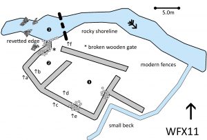
WFX11 Far Easedale Gill, lower, Grasmere
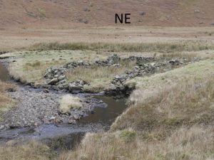
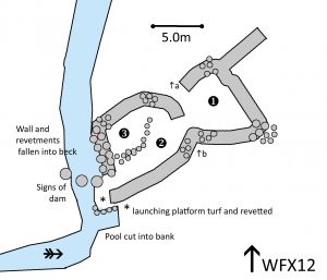
WFX12 Far Easedale Gill, upper, Grasmere
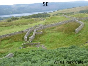
WFX1 in Area 11 Above Park Gate, Coniston
Washfold above Park Gate on a feeder beck to Coniston Water. The fold is located at SD 29041 96406 at an altitude of 212m above sea level. The dam linked to the site is at SD 28799 96266. We have no information from the National Park Heritage Environment Record on either site and it is outside the area surveyed in the Duddon Valley Local History Group survey, Ring Cairns to Reservoirs (R2R) survey in 2009. It is in Westmorland and Furness, previously South Lakes. Its condition is good and the certainty that it is a washfold is good.
Constructed from quarried and glacial stones.
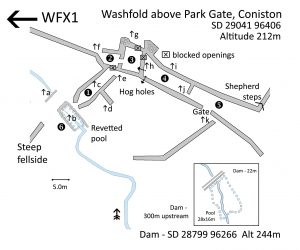 Click on plan to enlarge then use back arrow to return to this page
Dimensions:
Chamber 1- 12×3.5m; chamber 2- 6.0×4.0m; chamber3- 7.5×5.5m; chamber 4- 14.0×5.0m; Pool- 7.5×3.5m
Wall heights: a 0.9m; b 1.0m; c 1.2m; d 1.2m; e 1.4m; f 1.3m; g 1.0m; h 2.4m; i 1.4m; j 1.4m; k 1.7m
Description:
The washfold is on one side of the fell wall with a number of buildings and enclosures on the other side. It looks more like an industrial than an agricultural setting but the build may well have been by quarrymen or miners. Chamber 1 comes to the exit to the pool with nicely curved walling. The exit through the fell wall is blocked. The pool is an oblong with revetted walls and a paved bottom coming down a ramp to the deep end. There is culvert leading under a three metre wide bridge from the track to the washfold entrance to drain the pool.
300 metres up the beck there is a dam and a marshy area which would have supplied a head of water to fill the lower pool. The dam consists of two parallel walls with about one metre showing above the ground surface. The interior has been packed with turf and stones – common practice in the local copper mining area. There is a culvert in the centre of the dam that has been partially washed out showing its construction between the walls . Damming the culvert would have created a large pool within natural and some man-made banks.
There are several other blocked openings on the east of the wall and the fell wall which can only be crossed through a gateway. The only access from areas 4 and 5 into the northern areas is over a set of shepherd steps in the wall corner. Area 2 leads into what appears to have been a barn (3) with a gable wall at the southern end and brick piers which may have supported a roof or be part of stalls. It is so full of bracken and tumble that it is not easy to see what is going on.
Recorded by: Stephe Cove and Dave Hughes on 28th July 2022
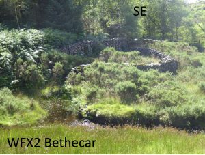
WFX2 in Area 11 Bethecar above Nibthwaite Grange
Washfold close to Arklid Intake on an unamed beck that eventually joins Colton Beck. The fold is located at SD 30870 89401 at an altitude of 190m above sea level. We have no information about whether it is recorded in the National Park Heritage Environment Record and it is outside the area surveyed in the Duddon Valley Local History Group survey, Ring Cairns to Reservoirs (R2R) survey in 2009. It is in Westmorland and Furness, previously South Lakeland. Its condition is good and the certainty that it is a washfold is good.
Constructed from natural stones largely rounded in shape
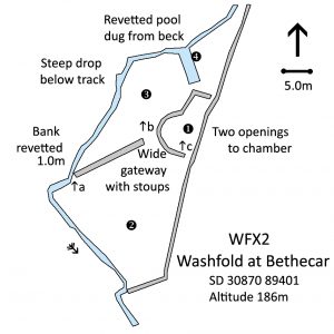
Click on plan to enlarge then use back arrow to return to this page
Dimensions:
Chamber 1- 10.0×6.5m; area 2- 20.0×16.0m; area 3- 20.0×9.5m; pool 4- 5.7×2.0mm
Wall heights: a 1.2m; b 1.1m; c 0.9m; d 1.1m
Description:
There is one chamber bordered on the east by the wall around the Arklid Intake plantation. There are two partially enclosed areas. There is an entrance from area two and an exit opening to the pool. The entrance to area 2 from area 3 is wide with two gate stoups but no gate. The area is puzzling because it is open to the beck along the whole south-western side. Area 3 is open to the beck and beyond the pool. The far side of the beck is revetted to a height of 1.0m at the bottom of a steep bank leading up to the track. The pool is quite unusual. The fold is some seven metres from the beck and there is a revetted channel at right angles to the flow bringing the pool to the launching platform. All of the area is heavily overgrown with gorse and it is quite difficult to get around once the beck has been crossed.
Recorded by: Stephe Cove and Dave Hughes on 4th August 2022
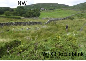
WFX3 in Area 11 Tottlebank, above Blawith
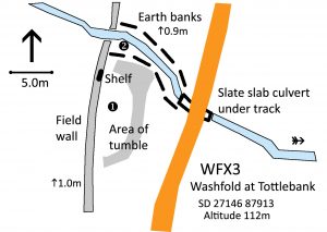
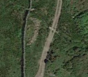
Washfold at Tottlebank on Black Moss Beck. The fold is located at SD 27146 87913 at an altitude of 112m above sea level. We have no information from the National Park Heritage Environment Record and it is outside the area surveyed in the Duddon Valley Local History Group survey, Ring Cairns to Reservoirs (R2R) survey in 2009. It is in Westmorland and Furness, previously South Lakes. Its condition is poor and the certainty that it is a washfold is good.
Constructed from quarried and glacial stones.
Click on plan to enlarge then use back arrow to return to this page
Dimensions:
Chamber 1- 11.5×4.3m; Pool- narrow beck at present but 11.0×3.5m possible extent
Field wall height: 1.2m
Description:
This is the fold mentioned in the article about hare hunting on 5th December, 1901 (https://www.duddonhistory.org.uk/washfolds-mentioned-in-the-press/ ). There is now nothing more than a low pile of rubble with two clear openings against the field wall. There is well built shelf in the wall close to the exit to the pool. The beck is running in a narrow channel but earth banks on either side indicate the size of the pool possible if the beck were dammed at the culvert. The culvert is well made using slate slabs as a clapper bridge.
Recorded by: Stephe Cove and Dave Hughes on 4th August, 2022
WFX4 in Area 11 Stockdale Moor, East of Cold Fell Road
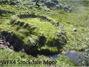
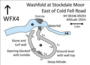
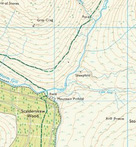
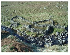
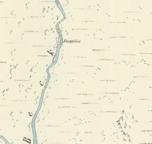
Washfold on Stockdale Moor on Cawfell Beck a feeder beck to Worm Gill. The fold is located at NY 09246 09293 at an altitude of 192m above sea level. It is 33715 in the National Park Heritage Environment Record and it is outside the area surveyed in the Duddon Valley Local History Group survey, Ring Cairns to Reservoirs (R2R) survey in 2009. It is Cumberland, previously Copeland. Its condition is good and the certainty that it is a washfold is good.
Constructed from glacial stones, beck boulders and turf. There is a small outcrop at the end of the wall above the beck.
Click on plan to enlarge then use back arrow to return to this page
Dimensions (by pacing):
Chamber 1- 12.5×5.5m; Pool- 7.0mx4.0m, depth at least 2.5m
Wall heights: a 1.2m; b 1.0m; c 1.2m; d 0.8m; e 1.2m; f 0.8m; g 0.6m; h 0.2m; I 1.8m
Description:
A remote location on the side of a steep gully leading down to Worm Gill. Clearly, this was a more important place in the past as it is less than 500m from the large mountain pinfold on the edge of Scalderskew Wood. The chamber is sloping and the turf walls are generally higher on the outside than within. The southern wall has the fell side level with the top of the stones. The pool is enormous and too deep to measure with lots of small trout swimming in it. On a scorching day, I couldn’t resist the temptation to have the full sheep experience and jump in from the launching platform!
Recorded by: Stephe Cove on 12th August, 2022
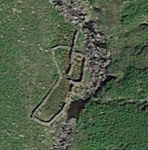
WFX5 in Area 11 Over Beck, Wasdale
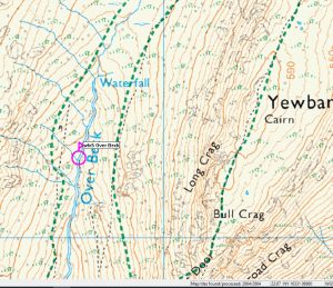
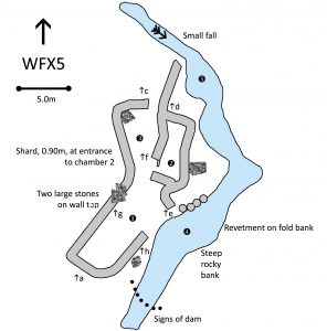
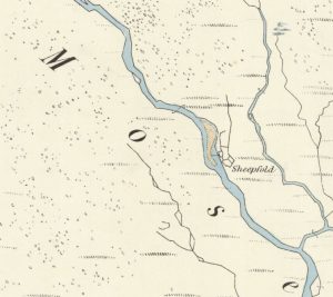
Washfold on Over Beck leading to Wastwater. The fold is located at NY 16719 08463 at an altitude of 318m above sea level. It is 34968 in the National Park Heritage Environment Record and it is outside the area surveyed in the Duddon Valley Local History Group survey, Ring Cairns to Reservoirs (R2R) survey in 2009. It is in Cumberland, previously Copeland. Its condition is good and the certainty that it is a washfold is good.
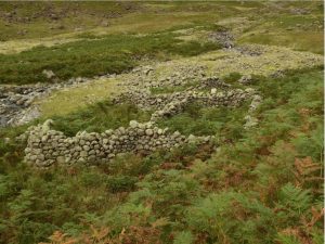
Constructed from field and beck boulders with some large slabs outcropping
Click on plan to enlarge then use back arrow to return to this page
Dimensions (by pacing):
Chamber 1- 10.0 x 3.5m; chamber 2- 5.5 x 2.5m; chamber 3- 6.5 x 3.5m; pool 4- 7.0×3.0m;
Wall heights: a 0.9m; b 0.3m; c 1.2m; d 1.3m; e 3.0m to pool; f 1.5m; g 1.3m; h 2.6m
Description:
A three-chambered fold with a short gathering wall on the corner of a fast flowing beck. There is a wide gap in chamber 1 leading to the beck with a long drop to the current water level. There are signs of a dam and a length of revetment along a flat area suggesting a much larger pool could be created. There a tall shard partially blocking the entrance to chamber 2.
Recorded by: Stephe Cove on 19th September, 2022
WFX6 in Area 11 Mosedale, Wasdale Head
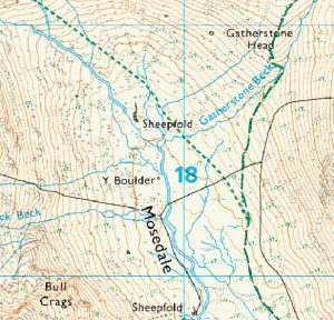
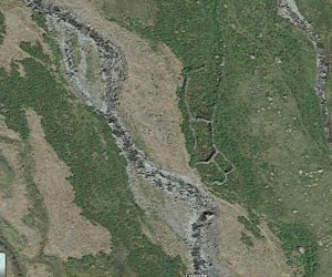
Washfold near the Y Boulder on the Mosedale Beck. The fold is located at NY 24711 01728 at an altitude of 220m above sea level. It is 34800 in the National Park Heritage Environment Record and it is outside the area surveyed in the Duddon Valley Local History Group survey, Ring Cairns to Reservoirs (R2R) survey in 2009. It is in Cumberland, previously Copeland. Its condition is medium to poor and the certainty that it is a washfold is good.
Constructed from field boulders
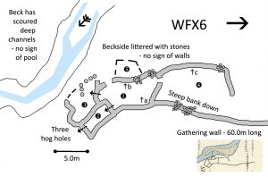 Click on plan to enlarge then use back arrow to return to this page
Dimensions measured (by pacing):
Chamber 1- 6.5 x 3.5m; chamber 2- 4.5 x 3.0m; chamber 3- 4.0 x 3.5m; chamber 4- 11.5 x 8.5m; chamber 5- 5.0 x3.0 (from map)
Wall heights: a 1.8m; b 1.8m; c 0.9m;
Description:
Washfold in reasonable condition apart from on the walls nearest to the beck. Those shown on the old map sheets are no longer evident. There is a litter of stones on the level between the fold and the water which is now in a deep channel scoured out of the fellside. There is no evidence of where a pool may have been. The gathering wall stretches for about 60 metres north up the valley. There is a second wall creating an open chamber 4 with a steep bank down into it. Chamber 1 opens towards the beck and has hog holes leading into chambers 2 and 3. Chamber 2 is completely enclosed with a second hog hole leading to the fell. All the chambers are heavily infested with bracken and rush
Recorded by: Stephe Cove on 19th September, 2022
WFX7 in Area 11 Netherbeck, Wasdale
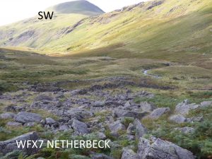
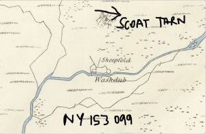
Washfold on outlet from Scoat Tarn leading to Netherbeck. The fold is located at NY 15270 09890 at an altitude of 435m above sea level. It is 61122 in the Lake District Heritage Environment Record and it is outside the area surveyed in the Duddon Valley Local History Group survey, Ring Cairns to Reservoirs (R2R) survey in 2009. It is in Cumberland, previously Copeland. Its condition is good and the certainty that it is a washfold is good.
Constructed from natural stones. There is a large triangular slab as wall topping in chamber 3.
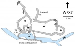 Click on plan to enlarge then use back arrow to return to this page
Dimensions (by pacing):
Chamber 1- 3.0×3.0m; chamber 2- 6.0×4.0m; chamber 3- 11.5×4.5m; chamber 4- 3.0×3.0m; pool 6.0×4.0m
Wall heights: a 1.1m from beck bed to launching stone; b 1.2m; c 1.6m; d 1.2m; e 0.5m
Description:
A substantial fold in a remote location with four chambers and two gathering walls. There is a large launching stone above a deep pool which has evidence of damming at both ends and a substantial stone revetment on the far side of the beck. It is now clogged with rush and the wall is tumbling in a few places. There is a hog hole from chamber 2.
Recorded by: Stephe Cove, 15th September 2022
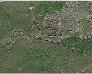
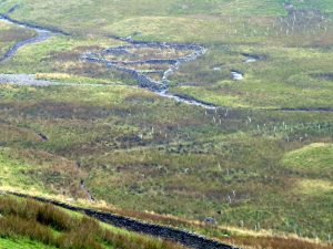
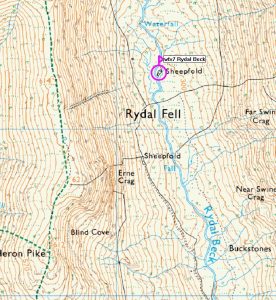
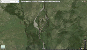
WFX8 in Area 11 Rydal Beck below High Pike
Washfold on Rydal Beck. The fold is located at NY 36216 09169 at an altitude of 296m above sea level. We have no information from the National Park Heritage Environment Record and it is outside the area surveyed in the Duddon Valley Local History Group survey, Ring Cairns to Reservoirs (R2R) survey in 2009. It is in Westmorland and Furness, previously South Lakeland. Its condition is good and the certainty that it is a washfold is good.
Constructed from field boulders
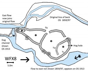 Click on plan to enlarge then use back arrow to return to this page
Dimensions:
Chamber 1- 4.0×2.5m; chamber 2- 16.5 x 9.8m; chamber 3- 20.5 x 15.0m; chamber 4- 11.0×7.0m; pool 5- 6.0×4.0m;
Wall heights: a 2.0m from beck surface; b 1.0m; c 1.5m; d 0.5m;
Description:
A remote washfold at the head of the valley with four chambers and an unusual overall shape. The earliest maps show the beck running south on the western side of the fold and there is still a flow right up to bottom of the outer wall of chamber 1. On the 1913 edition, a channel is shown to the east of the fold with a revetted channel taking the flow quite a way south before joining with th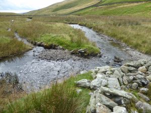 e main beck. This channel has broken through to the beck now at the entrance to chamber 1.
The eastern channel was now the major flow on our visit. There are two large chambers, 2 and 3, with a smaller one at the top where the wall is mostly rubble. A hoghole leaves this chamber. Unusually it has timber lintels both inside and outside. There is no sign of any wall to the north as shown on the modern map but not on any of the earlier editions.
Recorded by: Stephe Cove and Dave Hughes on 15th September, 2022
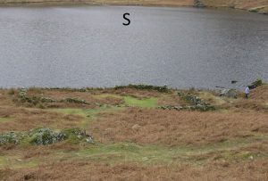
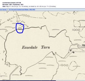
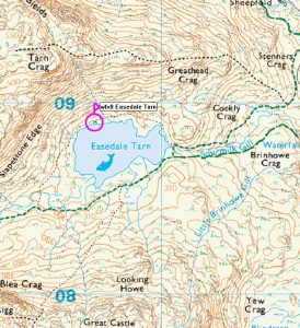
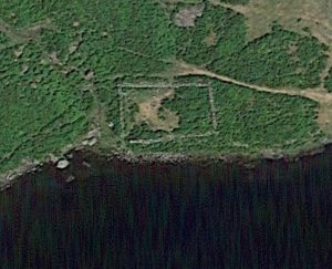
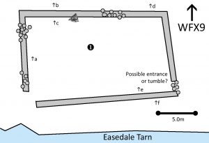
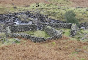
WFX9 in Area 11 Easedale Tarn, Grasmere
Washfold on the north bank of the Tarn. The fold is located at NY 30647 08899 at an altitude of 284m above sea level. We have no reference from the Historic Environment Record. It is in Westmorland and Furness, previously South Lakes. Its condition is medium and the certainty that it is a washfold is good.
Constructed from glacial stones.
Dimensions:
Chamber 1- 17.8×10.7m
Wall heights: a 1.0m; b 0.0m; c 1.1m; d 1.0m; e 0.0m; f 1.0m
Description:
A large single rectangular chamber close to the edge of the tarn. There is a large stony gap to the water’s edge. There is one clear opening to the west with the remains of an iron gate. The eastern end has a possible entrance blocked by tumble stones but it may just be a collapse of the wall. The northern wall is cut into a bank for some of its length with the wall top level with the ground. A reference to this fold refers to the need for a boat during washing to ensure the sheep return to the near bank rather than swimming out into the tarn.
Recorded by: Stephe Cove, Dave Hughes and Philip Minchom on 12th February, 2023
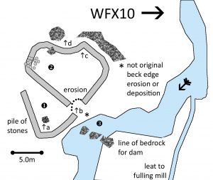
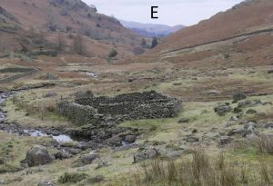
WFX10 in Area 11 Sour Milk Gill, Grasmere
Washfold on Sour Milk Gill below the waterfall. The fold is located at NY 31879 07811 at an altitude of 124m above sea level. It is 61311 in the national Park Historic Environment Record. It is in Westmorland and Furness, previously South Lakes. Its condition is good and the certainty that it is a washfold is good.
Constructed from quarried and glacial stones and incorporating bedrock into the northern wall. There are large boulders and a small outcrop utilised in the beck for a dam.

