WASHFOLD HOME PAGE ——WASHFOLD AREA MAPS PAGE —— WASHFOLD SURVEY PAGE
These are the Cockley Beck washfolds
WF1 Gaitscale Gill
WF2 Cockley Beck
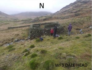
WF3 Above Dale Head
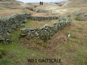
WF1 in Area 1, Gaitscale, Wrynose Bottom
Washfold at Wrynose Bottom on Gaitscale Gill. The fold is located at NY 25673 02281 at an altitude of 274m above sea level. It is recorded in the National Park Heritage Environment Record as 38744 but not recorded in the Duddon Valley Local History Group survey, Ring Cairns to Reservoirs (R2R) survey in 2009. It is in Cumberland, previously Copeland. Its condition is good and the certainty that it is a washfold is good.
Constructed from field boulders
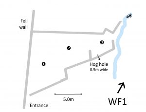
Click on plan to enlarge then use back arrow to return to this page
Click on plan to enlarge then use back arrow to return to this page
Dimensions: chamber 1- 9.0×5.0m; chamber 2- 5.0×4.0m; chamber3- 4.0×3.0m
Wall heights: generally 1.35m
Description:
Situated on open fell rising steeply to the north. Hog hole in chamber 3. Possible driving wall from open fell to the west. Steepish descent to the beck 1.5-2.0m
Recorded by: Rob Mckeever, Barbara Green, John Jordan and Dave Hughes on 17th March, 2022
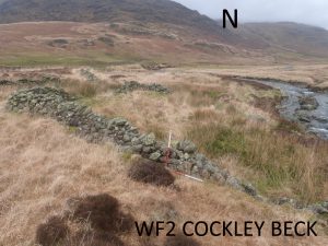
Washfold at Cockley Beck on the River Duddon. The fold is located at NY 24711 01728 at an altitude of 220m above sea level. It is recorded in the National Park Heritage Environment Record as 61094 but not recorded in the Duddon Valley Local History Group survey, Ring Cairns to Reservoirs (R2R) survey in 2009. It is in Cumberland, previously Copeland. Its condition is medium and the certainty that it is a washfold is good.
Constructed from field boulders
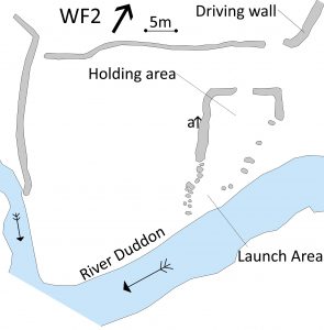
Click on plan to enlarge then use back arrow to return to this page
Dimensions: chamber 1- 18.0×10.0m
Wall heights: a 1.1m
Description:
Washfold in moderate conditon with some walls partially collapsed. Situated on open fell. No Hog Hole. Possible driving wall from open fell to the North. Possible evidence of a dam to create depth. Large outer walled area which was possibly an additional holding area for the washfold.
Recorded by: Rob Mckeever, Dave Hughes, Barbara Green and John Jordan on 17th March, 2022
WF3 in Area 1, Dale Head Close
Washfold at Dale Head Close on a feeder beck to Dale Head Gill. The fold is located at NY 24370 00586 at an altitude of 223m above sea level. It is recorded in the National Park Heritage Environment Record as 36586 but was not recorded in the Duddon Valley Local History Group survey, Ring Cairns to Reservoirs (R2R) survey in 2009. It is in Westmorland and Furness, previously South Lakes. Its condition is good and the certainty that it is a washfold is good.
Constructed from field boulders.
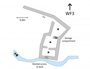
Click on plan to enlarge then use back arrow to return to this page
Dimensions: chamber 1- 7.0×6.0m; chamber 2- 7.0×5.0m; chamber 3- 7.0×3.0m
Wall heights: 1.5m throughout
Wall width: 0.5-0.8m
Description:
Washfold in excellent condition. Situated in open fell rising steeply to the east. Gathering wall and three chambers. Exit to beck blocked up with stonework. Storage hole through wall. No hog hole
Recorded by: Rob Mckeever, Dave Hughes, Barbara Green and John Jordan on 17th March, 2022
WASHFOLD HOME PAGE ——WASHFOLD AREA MAPS PAGE —— WASHFOLD SURVEY PAGE

