Saturday 20th May 2017: Broughton Mills circular via Haws, Picthall Ground and Croglinghurst – Ken Day
Starting from Broughton Mills village hall car park and passing by the old corn mill, this end of season 4 miles stroll took in a potash pit, a fine example of a cruik barn, retting ponds with drainage tunnel and filter bed and enigmatic field structures before veering off to the farming hamlet at Croglinghurst. At the end of the walk and passing beyond the old wood mill there was the unexpected bonus of the well preserved lime kiln hidden at the bottom of a Shop Street garden! And this excellent walk was completed in fine style by a visit to the Blacksmiths Arms for a well-deserved lunch.
A really interesting and entertaining outing. Thanks Ken.
13th May 2017: Torver, Hare Crag and High Common – Alison Matthews
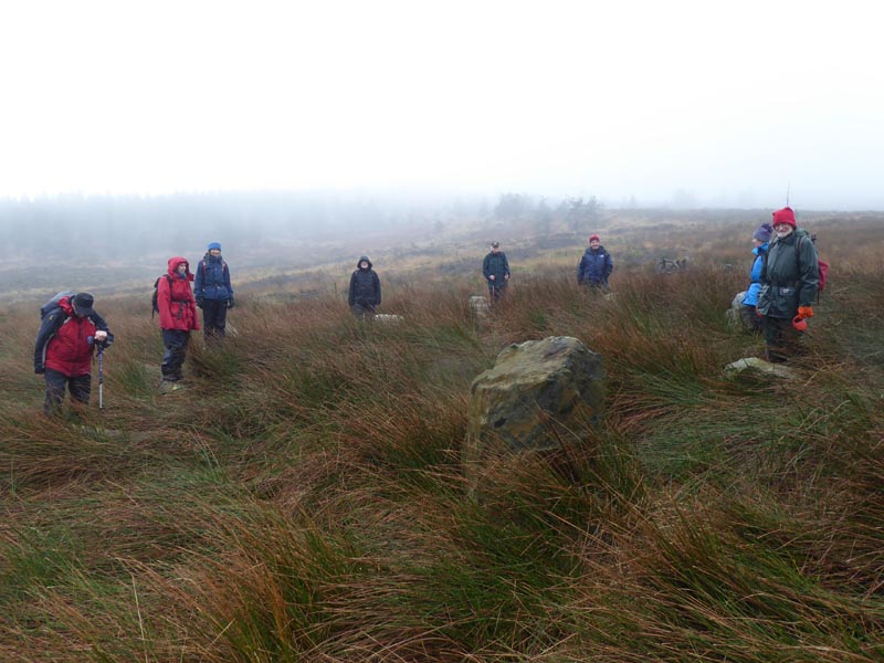
Set off from the junction of main A593 road and Crook Barn turning, to climb up to the summit of Hare Crags (820 ft) to view an earth circle with shallow depressions on both inner and outer sides. Views from here are amazing with an outlook over the Torver valley and in the opposite direction to the summits of Dow Crag and the Old Man. Perhaps this was a place of worship but nothing definite is known.
Continued on, passing by spoil tips, to Bannishead slate quarry with the quarry floor some 50 feet below now flooded, hiding the tunnel exit below the water line where slate was removed. The tunnel emerges in a long cutting leading downhill that once was a roadway out of the quarry.
We moved on to the High Common to find Bannishead stone circle. Further on there are the remains of what was later identified as rifle butts which were used by various volunteer corps until at least 1916. A structure to the west of them may have been connected with grouse shooting.
An excellent and interesting day out. Thanks Alison.
6th May 2017: Kirkby Moor from the Railway Station – Sue Batten
An entertaining walk starting by crossing the railway line to walk along the foreshore before recrossing the line and turning inland via Cart House and taking in the history of Soutergate and Beck Side and up on to Kirkby Moor to find, in a slight depression, large scattered pieces of slate set out in a boat shape. A subject for speculation.
Stunning views of the Duddon estuary and the mosses on the way back downhill, passing by Kirkby Hall and the inclined trackway that provided transport from the slate quarries to the port and later to the railway at Sandside.
Thanks to Sue for an entertaining walk and for the history of Soutergate.
1st April 2017: A Satterthwaite Circular – Alan Westall
18th March 2017: Stone Circle Find or Not? – Gail Batten
Weather wet and raining, 7 degrees C, low cloud and mist.
Undeterred by the conditions, Gail led us from the shelter of the parish room passing by the site of the old carding mill and on beyond the Newfield to a track through woodland to arrive at the river bank and the Memorial Bridge. This fine stone bridge over the Duddon built in memory of Aida Borchgrevink, a resident of the valley in the early years of the last century, was commissioned by her daughter and built in 1933. The plaque on the wall of the bridge has Aida’s initials (AB) and Greek letters alpha and omega intertwined with a star (her maiden name was Starr).
We crossed the bridge to pass High Wallowbarrow Farm, noting harr-hung gates in passing, to climb up the slope and over the fell with the track flanked by splendid and substantial walling on the approach to Grassguards farm. Here we stopped to take shelter in the barn, courtesy of the kind owner who took pity on us.
After a brief respite we set off again following a forestry road to see a stone circle, situated in a convenient location just beside the road. General consensus was that the circle was constructed in the recent past for a bit of fun, a view reinforced when discovering that the prop for one of the stones was loose causing the stone to wobble. Just our opinion, of course.
On the return journey we paused on the slope above Wallowbarrow farm to be shown the outlines of ancient retting ponds in the valley bottom. Near where we stopped was what seems to be an earth platform – for storage perhaps? Returned via Tarn Beck, in spate now, passing by remains of sluice gates that once controlled water flow into the carding mill race.
A very interesting walk and worth repeating, although maybe in drier conditions.
Ron
Saturday 4th March 2017: Bardsea to Urswick via Sunbrick – Peter Greenwood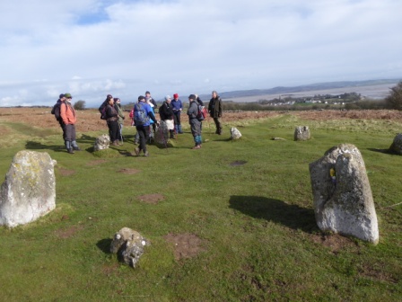
Weather fine and dry, 7 degrees C, light breeze, visibility good.
Peter led us from Bardsea sea front car park to walk past C17th Wellhouse and uphill onto Birkrigg Common to visit the Druids circle, one of the few double stone circles in Britain. Excavation here in 1900 revealed evidence of several cremations and an urn. Uphill next, with skylarks singing overhead, to the site of a Bronze Age settlement surrounded by an earth bank and with tumuli nearby.
The walled Quaker burial ground at Sunbrick was our next stop. This must have been a significant settlement in the C17th because George Fox is reputed to have visited and his wife Margaret Fox is buried here. We moved further towards the top of Birkrigg and the trig point to enjoy fine views of distant fells in front of us and light reflecting from the wet sands of the bay behind.
Heading for Urswick, we had to pause while Lindsay who was determined to see St Michael’s Stirrup stone that was hidden in the vegetation beat aside accumulations of bracken until he uncovered the approx one metre high standing stone, below.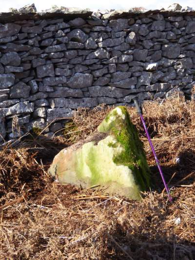
In Urswick we called in at the church with its square tower, the lower part pre-Norman, to admire the C12th Norman font, the wood carvings, the stained glass, and the C10th Viking cross shaft uncovered during building work in 1911. Close by the church we saw the priapus stone, incongruously forming part of the roadside wall, and then continued onwards to visit Urswick Stone Walls Iron Age settlement and burial chambers.
On our return journey to Bardsea Peter took us on a detour to visit Skelmore Heads Bronze Age hill fort and the nearby remains of a barrow with just two standing stones visible. We then passed the site of what once was Bardsea Hall (demolished 90 years ago and now home to a golf club) whose owner Nicholas Bardsea was killed during the civil war in 1642. Subsequent inhabitants continued to be involved in religious and political conflict during the C17th and early C18th periods.
A very satisfying walk, full of interest and completed just before rain started.
Ron
Saturday 18th February 2017: The Hawk and Stephenson Ground Scale – Mervyn Cooper
Though overcast, rain held off and 11 of us set off through the forest up to The Hawk. This is a wall enclosed settlement site dating to the early centuries A.D. (or possibly Iron Age) – and includes 4 roundhouses, one of which has been excavated. Bracken clearance by DVLHG volunteers over the past few years has made a remarkable improvement to the appearance of the site.
Walk continued up past Natty Bridge and then turning south into Stephenson Ground Scale. Here guided by a site brochure from Broughton TIC, we visited the Double-walled Medieval Longhouse, the Bronze-age Round House, the early Medieval (possibly Viking) Longhouse and Bronze – age cairns (probably burial).
Walk returned past Stevenson Ground Farm – where the Water Yeat(s) constructed of hexagonal Rhyolite bars, quarried locally, were of interest.
An enjoyable day.
Mervyn
4th Feb 2017: Hampsfell and Cartmel Priory – Bob Bell
This walk set out to visit the Hospice (refuge) on Hampsfell above the village of Cartmel followed by a short visit to Cartmel Priory. A total of 14 walkers undertook the journey. The route chosen commenced through muddy fields belonging to Pitt Farm where the Moffatt family train racehorses including their current stable star Highland Lodge – the 2015 winner of the Becher Chase at Aintree and an entrant for the 2017 Grand National.
Following a very wet start the walk continued up the fell over a limestone terrace where underfoot conditions were much improved. After a straightforward climb in relatively good weather, there was an unexpected deterioration and as rain fell the walking party had no alternative but to take refuge in the hospice as the heavens opened. This gave an opportunity for the party to read the poetry on the walls of the refuge as they ate their sandwiches. George Remington vicar of Cartmel who had the refuge built in 1834 for the benefit of wanderers caught out on the fell by bad weather would have been pleased to know that in the year 2017 his creation had served its intended purpose for the benefit of a group of walkers caught out by a sudden quite severe rain shower which had not been forecast. Some of the more intrepid walkers climbed to the roof of the refuge to use the toposcope (wooden pointer on a plinth spinning from 0 to 360 degrees) for the purpose of identifying the surrounding mountains.
Because of the unexpected poor weather the party decided that the driest route down would be to walk the top of the ridge in a westerly direction – at which point the weather miraculously improved and the group had a memorable ridge walk with very fine views of Morecambe Bay. The party then headed downhill toward Cartmel village following a route which included a public footpath through Cartmel Fell golf course. There was some difficulty in locating the ladder stile where the footpath through the golf course commenced. Happily Piers Waterston displayed his map reading skills and the correct stile was located.
Following a change out of muddy boots many of the party continued with a visit to the Priory church. With the assistance of the church steward’s notes I pointed out some of the unusual features of the church – including the loaf of bread left out each day – in accordance with the will of a deceased local benefactor to be given to the most indigent in the parish. I finally concentrated on the Italian marble memorial to Lord Frederick Cavendish who was murdered in Phoenix Park, Dublin on 6th May 1882 – the same day as he had landed in Ireland to take up office as Chief Secretary. He was murdered together with the Permanent Undersecretary Thomas Burke who was the real target of an Irish Nationalist secret society – The Invincibles. I told the story of the murder, the investigation which led to a member of the terrorist group turning Queen’s Evidence and the conviction of 6 of the assassins. They were executed whilst the informer was also subsequently killed in South Africa by another supporter of The Invincibles. He in turn was arrested, brought back to England, convicted and hanged. Many of these events were a foretaste of what was to be repeated so many times in subsequent Irish history during the struggle for independence from the 1916 Easter Rising to the partition of Ireland in 1922 and in subsequent “Troubles”:
- The murder of an innocent man (in this case Lord Cavendish) who happened to be in the wrong place at the wrong time.
- A terrorist act which was followed by a police investigation and the use of informers who agreed to give evidence in return for immunity.
- Executions which inspired future generations to continue the armed struggle to obtain independence rather than working for political change through Parliament and democratic means.
- The murder of the informer by Irish terrorists even though he had been given a new identity and sent with his wife and family to far away South Africa.
The morale therefore is that the next generation never seems to learn from the mistakes made by the previous generation. Such is the course of history.
Bob
19th November 2016: Rowrah to Egremont – Stephe Cove
This was a walk through the history of West Cumbria with almost all the evidence missing – rather like walking across Salisbury Plain with no sign of Stonehenge. The mines and quarries have left little evidence visible apart from the disused railway lines linking the mines down through Moor Row (the Crewe of West Cumbria) to Whitehaven docks and the Workington steel works.
We set off from Rowrah which was originally connected by three separate railway companies, two of which terminated in Rowrah thus giving four separate lines into and out of Rowrah for passengers and goods where nothing remains but overgrown sidings and redundant bridges. We strolled down the hill along the old route passing derelict stations and the landscape evidence of the old mines with only an occasional block or two of red sandstone to show the sites of buildings.
At Egremont, the drivers were ferried back to the start to collect the cars while the rest of the party discovered that there were no cafes open in the whole of the time. I was glad that I was driving!
Stephe
5th November 2016: Woodland Valley Industries – Dave Hughes
We were lucky to have a fine mild day. From the start, we looked at Woodland Church and then at Church House and School House. We walked through Raisthwaite Farm and on to the fell to Spindle Tree and Green Moor. We climbed through the bracken to the Conscientious Objector’s Stone which has now got listed status from English Heritage. On to the Bloomeries where the ground is full of mounds of slag and the aftermath of the early iron industry. From Monks Way we went through to Climb Stile Farm past the disused Retting pond where flax was rotted down prior to carding. The last leg was past the Village Hall and through Row Ridding Wood and back to the start – 7 miles
Dave
15th October 2016: Castlerigg Stone Circle – Ken Day
The plan was for everyone to meet up at the car park to St Johns in the Vale Church. Those arriving early managed to claim a place for as luck would have it, this was the very day that the local hounds’ trail was out in force, with vehicles parked at every available space in the car park and all along the service track. But somehow we all managed to squeeze in.
It was a bright autumnal day. With just one person missing, thirteen of us set off west in the direction of Kendal. After about 400 yards we met Alison, walking towards us. She had attempted to approach St John’s from the opposite direction on what from the map, appeared to be a good road. On finding it impassable she abandoned her car and walked to rest of the way to join the merry band of travellers.
This turned out to be a very pleasant stroll across open fields, with cattle grazing and birds singing. We followed the clearly marked footpath, west down past the outskirts of Sykes farm and then a gentle incline to Nest Brow, hitting the A591 for 20 yards before turning right towards High Nest, continuing on for about a mile to the tarmacked road a few yards east of Castlerigg, pre-historic stone circle. There we were greeted with a magnificent panorama of the Lake District’s Northern Fells, with Great Dodd and the Helvellyn ranges to our fore and Skiddaw with Blencathra behind us. A great place for lunch and take in all around us.
Then it was back to the road and east to Naddle Bridge and then right, back towards St John’s, picking up the footpath heading for Low Rigg and then dropping down to our start, all the while enjoying glorious weather and magnificent scenery. With time on our side, we then drove to Threlkeld Mining Museum (thoroughly recommended) just off the B5322 about half a mile south of the A66. There, having looked at the fascinating mining exhibits we took the narrow gauge rail trip to Threlkeld Quarry, where a most knowledgable young man gave us a talk on the history of quarrying in the area. Returning to the museum to be reunited with our cars it brought a most enjoyable day to an end.
Ken
1st October 2016: Over Hill and Dale – Sue Lydon
On October 16th 2016 Sue Lydon led a walk “Over Hill and Dale”. This was an easy 5 mile walk taking about 4 hours. Starting from Old Hall Farm we walked up through the wood on to Colton Heights where the views of the Coniston Fells are spectacular. Then on down to Colton church with its mounting stone still in situ, for a brief look round and a short history of life among the church regulars. Further down a track is a reinforced “well” , a spring named St Cuthbert’s Well by the monks of Furness Abbey, and where they drew the “holy” water for baptisms.
From there we retraced our steps up the hill and then continued across several fields to Low Longmire Mill. This was the perfect place to stop for lunch, sitting by the mill pond. This nineteenth century mill was used by the older Low Longmire Farm across the fields for milling corn.
Hay Bridge museum was the next stopping point, and then on back to Old Hall Farm through fields and woods where tea and cake tempted us.
Sue